Łęczyce geodata
Łęczyce (Pomerania) is a populated place; located in Poland in Europe/Warsaw (GMT+2) time zone. With population of 1,524 people, there are 1824 cities with bigger population in this country. Compared to other cities in Poland, 99.1% of cities are located further ↓South; 76.6% of cities are located further →East and 96.1% of cities have higher elevation than Łęczyce. Note1


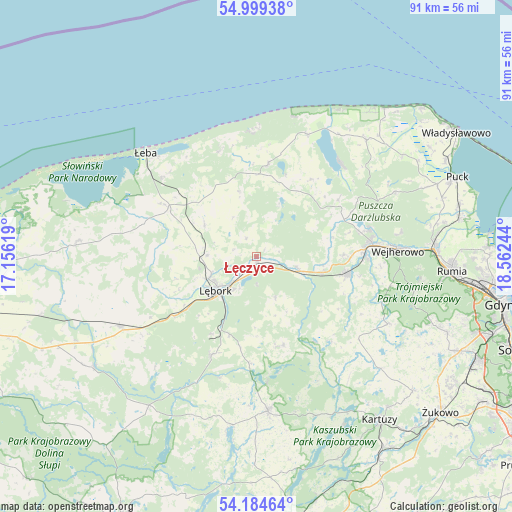
Łęczyce GPS coordinates[2]
54° 35' 38.58" North, 17° 51' 33.516" East
| Map corner | latitude | longitude |
|---|---|---|
| Upper-left | 54.99938°, | 17.15619° |
| Center: | 54.59405°, | 17.85931° |
| Lower-right: | 54.18464°, | 18.56244° |
| Map W x H: | 90.6×90.6 km | = 56.3×56.3mi |
| max Lat: | 54.83135° ⇑0.9% North |
| Łęczyce: | 54.59405° |
| min Lat: | ⇓99.1% South 49.21328° |
| min Long | Łęczyce | max Long |
| 14.20249° | 17.85931° | 24.03723° |
| W 23.4%⇐ | ⇒76.6% E |
Elevation
Elevation of Łęczyce is 31 m = 102 ft, and this is 160.4 m = 526 ft below average elevation for this country.
| Max E: |
974 m = 3196 ft | 96.1% |
| Avg. | 191.4 m = 628 ft | |
| Łęczyce | 31 m = 102 ft | |
Min E: |
-3 m = -10 ft | 3.9% |
See also: Poland elevation on elevation.city.
Geographical zone
Łęczyce is located in North temperate zone (between Tropic of Cancer and the Arctic Circle). Distance of this North polar circle is 1330.9 km =827 mi to North.| Distance of | km | miles | from Łęczyce |
|---|---|---|---|
| North Pole | 3936.8 | 2446.2 | to North |
| Arctic Circle | 1330.9 | 827 | to North |
| Tropic Cancer | 3464.4 | 2152.7 | to South |
| Equator | 6070.3 | 3771.9 | to South |


Nearby cities:
15 places around Łęczyce: (largest is in red/bold)
• Bolszewo
20.6 km =12.8 mi,  82°
82°
• Cewice
19.4 km =12.1 mi,  204°
204°
• Choczewo
16.4 km =10.2 mi,  7°
7°
• Gniewino
17 km =10.6 mi,  36°
36°
• Gościcino
19.1 km =11.9 mi,  86°
86°
• Góra
17.1 km =10.6 mi, 75°
• Linia
16.6 km =10.3 mi,  162°
162°
• Luzino
16.4 km =10.2 mi,  100°
100°
• Lębork
9.3 km =5.8 mi,  229°
229°
• Maszewo Lęborskie
15.8 km =9.8 mi,  209°
209°
• Nowa Wieś Lęborska
9.4 km =5.8 mi,  245°
245°
• Orle
20.7 km =12.9 mi, 75°
• Rybno
17.7 km =11 mi,  55°
55°
• Wicko
17.7 km =11 mi,  298°
298°
• Wierzchucino
23.5 km =14.6 mi,  23°
23°
Sources, notices
• [Note1] Compared only with cities in Poland existing in our database
• [Src1] Map data: © OpenStreetMap contributors (CC-BY-SA)
• [Src2] Other city data from geonames.org with taken over terms of usage.
• [Src3] Geographical zone / Annual Mean Temperature by Robert A. Rohde @ Wikipedia
