Gniewino geodata
Gniewino (Pomerania) is a populated place; located in Poland in Europe/Warsaw (GMT+2) time zone. With population of 1,940 people, there are 1525 cities with bigger population in this country. Compared to other cities in Poland, 99.6% of cities are located further ↓South; 75% of cities are located further →East and 89.2% of cities have higher elevation than Gniewino. Note1


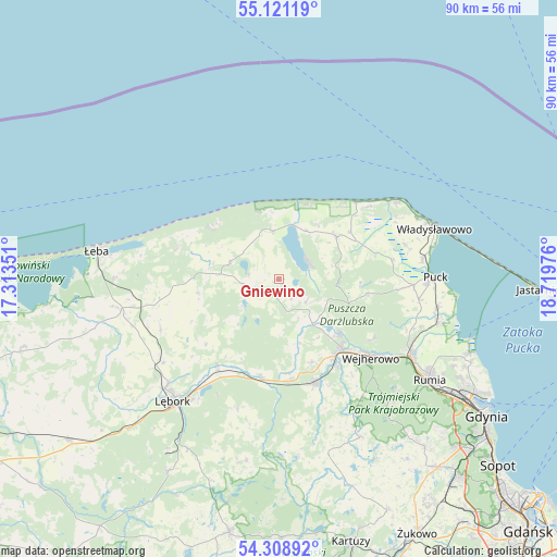
Gniewino GPS coordinates[2]
54° 43' 1.524" North, 18° 0' 59.868" East
| Map corner | latitude | longitude |
|---|---|---|
| Upper-left | 55.12119°, | 17.31351° |
| Center: | 54.71709°, | 18.01663° |
| Lower-right: | 54.30892°, | 18.71976° |
| Map W x H: | 90.3×90.3 km | = 56.1×56.1mi |
| max Lat: | 54.83135° ⇑0.4% North |
| Gniewino: | 54.71709° |
| min Lat: | ⇓99.6% South 49.21328° |
| min Long | Gniewino | max Long |
| 14.20249° | 18.01663° | 24.03723° |
| W 25%⇐ | ⇒75% E |
Elevation
Elevation of Gniewino is 78 m = 256 ft, and this is 113.4 m = 372 ft below average elevation for this country.
| Max E: |
974 m = 3196 ft | 89.2% |
| Avg. | 191.4 m = 628 ft | |
| Gniewino | 78 m = 256 ft | |
Min E: |
-3 m = -10 ft | 10.8% |
See also: Poland elevation on elevation.city.
Geographical zone
Gniewino is located in North temperate zone (between Tropic of Cancer and the Arctic Circle). Distance of this North polar circle is 1317.2 km =818.5 mi to North.| Distance of | km | miles | from Gniewino |
|---|---|---|---|
| North Pole | 3923.1 | 2437.7 | to North |
| Arctic Circle | 1317.2 | 818.5 | to North |
| Tropic Cancer | 3478.1 | 2161.2 | to South |
| Equator | 6084 | 3780.4 | to South |


Nearby cities:
15 places around Gniewino: (largest is in red/bold)
• Bolszewo
15 km =9.3 mi,  137°
137°
• Choczewo
8.4 km =5.2 mi,  287°
287°
• Gościcino
15.3 km =9.5 mi, 144°
• Góra
11.4 km =7.1 mi,  145°
145°
• Jastrzębia Góra
22.9 km =14.2 mi,  56°
56°
• Karwia
17.6 km =10.9 mi,  44°
44°
• Krokowa
11.6 km =7.2 mi,  53°
53°
• Luzino
17.8 km =11.1 mi,  160°
160°
• Orle
13.1 km =8.1 mi,  130°
130°
• Ostrowo
18.9 km =11.7 mi, 50°
• Rybno
5.8 km =3.6 mi, 129°
• Strzelno
21.2 km =13.2 mi,  68°
68°
• Wejherowo
18.8 km =11.7 mi, 131°
• Wierzchucino
7.9 km =4.9 mi,  353°
353°
• Łęczyce
17 km =10.6 mi,  216°
216°
Sources, notices
• [Note1] Compared only with cities in Poland existing in our database
• [Src1] Map data: © OpenStreetMap contributors (CC-BY-SA)
• [Src2] Other city data from geonames.org with taken over terms of usage.
• [Src3] Geographical zone / Annual Mean Temperature by Robert A. Rohde @ Wikipedia
