Głubczyce geodata
Głubczyce (Opole Voivodeship) is a seat of a second-order administrative division; located in Poland in Europe/Warsaw (GMT+2) time zone. With population of 13,697 people, there are 360 cities with bigger population in this country. Compared to other cities in Poland, 74.4% of cities are located further ↑North; 76.8% of cities are located further →East and 81.4% of cities have lower elevation than Głubczyce. Note1
Administrative division(s):
- Level 1: Opole Voivodeship
- Level 2: Powiat głubczycki
- Level 3: Głubczyce


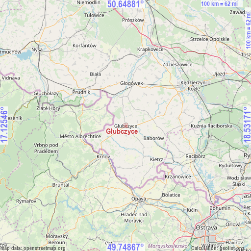
Głubczyce GPS coordinates[2]
50° 12' 3.096" North, 17° 49' 42.888" East
| Map corner | latitude | longitude |
|---|---|---|
| Upper-left | 50.64881°, | 17.12546° |
| Center: | 50.20086°, | 17.82858° |
| Lower-right: | 49.74867°, | 18.53171° |
| Map W x H: | 100.1×100.1 km | = 62.2×62.2mi |
| max Lat: | 54.83135° ⇑74.4% North |
| Głubczyce: | 50.20086° |
| min Lat: | ⇓25.6% South 49.21328° |
| min Long | Głubczyce | max Long |
| 14.20249° | 17.82858° | 24.03723° |
| W 23.2%⇐ | ⇒76.8% E |
Elevation
Elevation of Głubczyce is 273 m = 896 ft, and this is 81.6 m = 268 ft above average elevation for this country.
| Max E: |
974 m = 3196 ft | 18.6% |
| Głubczyce | 273 m 896 ft | |
| Avg. | 191.4 m = 628 ft | |
Min E: |
-3 m = -10 ft | 81.4% |
See also: Poland elevation on elevation.city.
Geographical zone
Głubczyce is located in North temperate zone (between Tropic of Cancer and the Arctic Circle). Distance of this North polar circle is 1819.4 km =1130.5 mi to North.| Distance of | km | miles | from Głubczyce |
|---|---|---|---|
| North Pole | 4425.2 | 2749.7 | to North |
| Arctic Circle | 1819.4 | 1130.5 | to North |
| Tropic Cancer | 2975.9 | 1849.1 | to South |
| Equator | 5581.8 | 3468.4 | to South |


Nearby cities:
15 places around Głubczyce: (largest is in red/bold)
• Baborów
12.1 km =7.5 mi,  113°
113°
• Branice
16.8 km =10.4 mi,  188°
188°
• Głogówek
17.2 km =10.7 mi,  8°
8°
• Kietrz
18.3 km =11.4 mi,  136°
136°
• Lubrza
20.8 km =12.9 mi,  316°
316°
• Maków
20.8 km =12.9 mi,  119°
119°
• Ostrożnica
18.7 km =11.6 mi,  75°
75°
• Pawłowiczki
16.5 km =10.3 mi,  72°
72°
• Pokrzywnica
22.1 km =13.7 mi,  48°
48°
• Polska Cerekiew
21.4 km =13.3 mi, 81°
• Prudnik
22.5 km =14 mi,  306°
306°
• Racławice Śląskie
12.9 km =8 mi,  342°
342°
• Rozkochów
20.5 km =12.7 mi,  22°
22°
• Twardawa
19.6 km =12.2 mi,  36°
36°
• Wysoka
19.7 km =12.2 mi,  182°
182°
Sources, notices
• [Note1] Compared only with cities in Poland existing in our database
• [Src1] Map data: © OpenStreetMap contributors (CC-BY-SA)
• [Src2] Other city data from geonames.org with taken over terms of usage.
• [Src3] Geographical zone / Annual Mean Temperature by Robert A. Rohde @ Wikipedia
