Lubsza geodata
Lubsza (Opole Voivodeship) is a seat of a third-order administrative division; located in Poland in Europe/Warsaw (GMT+2) time zone. With population of 1,375 people, there are 2004 cities with bigger population in this country. Compared to other cities in Poland, 57.3% of cities are located further ↑North; 79.6% of cities are located further →East and 64.1% of cities have higher elevation than Lubsza. Note1


Lubsza GPS coordinates[2]
50° 54' 57.276" North, 17° 31' 18.228" East
| Map corner | latitude | longitude |
|---|---|---|
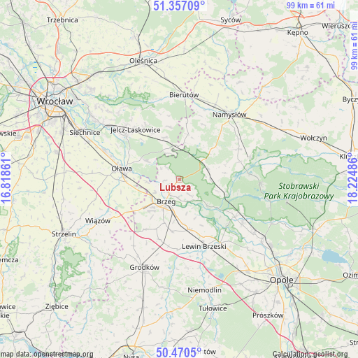
| Upper-left | 51.35709°, | 16.81861° |
| Center: | 50.91591°, | 17.52173° |
| Lower-right: | 50.4705°, | 18.22486° |
| Map W x H: | 98.6×98.6 km | = 61.3×61.3mi |
| max Lat: | 54.83135° ⇑57.3% North |
| Lubsza: | 50.91591° |
| min Lat: | ⇓42.7% South 49.21328° |
| min Long | Lubsza | max Long |
| 14.20249° | 17.52173° | 24.03723° |
| W 20.4%⇐ | ⇒79.6% E |
Elevation
Elevation of Lubsza is 136 m = 446 ft, and this is 55.4 m = 182 ft below average elevation for this country.
| Max E: |
974 m = 3196 ft | 64.1% |
| Avg. | 191.4 m = 628 ft | |
| Lubsza | 136 m = 446 ft | |
Min E: |
-3 m = -10 ft | 35.9% |
See also: Poland elevation on elevation.city.
Geographical zone
Lubsza is located in North temperate zone (between Tropic of Cancer and the Arctic Circle). Distance of this North polar circle is 1739.9 km =1081.1 mi to North.| Distance of | km | miles | from Lubsza |
|---|---|---|---|
| North Pole | 4345.7 | 2700.3 | to North |
| Arctic Circle | 1739.9 | 1081.1 | to North |
| Tropic Cancer | 3055.4 | 1898.5 | to South |
| Equator | 5661.3 | 3517.8 | to South |


Nearby cities:
15 places around Lubsza: (largest is in red/bold)
• Brzeg
7.2 km =4.5 mi,  211°
211°
• Bystrzyca
10 km =6.2 mi,  299°
299°
• Jelcz
18.3 km =11.4 mi,  309°
309°
• Jelcz Laskowice
18.5 km =11.5 mi, 309°
• Krzyżowice
12.7 km =7.9 mi,  198°
198°
• Minkowice Oławskie
12.2 km =7.6 mi,  339°
339°
• Miłocice
14.7 km =9.1 mi,  349°
349°
• Olszanka
13.8 km =8.6 mi,  192°
192°
• Osiek
16.4 km =10.2 mi,  258°
258°
• Oława
16.4 km =10.2 mi,  281°
281°
• Pogorzela
14.4 km =8.9 mi, 187°
• Popielów
18.5 km =11.5 mi,  122°
122°
• Skarbimierz Osiedle
10.6 km =6.6 mi,  222°
222°
• Łosiów
14.2 km =8.8 mi,  167°
167°
• Świerczów
17.3 km =10.7 mi,  73°
73°
Sources, notices
• [Note1] Compared only with cities in Poland existing in our database
• [Src1] Map data: © OpenStreetMap contributors (CC-BY-SA)
• [Src2] Other city data from geonames.org with taken over terms of usage.
• [Src3] Geographical zone / Annual Mean Temperature by Robert A. Rohde @ Wikipedia
