Olszanka geodata
Olszanka (Opole Voivodeship) is a seat of a third-order administrative division; located in Poland in Europe/Warsaw (GMT+2) time zone. With population of 447 people, there are 3569 cities with bigger population in this country. Compared to other cities in Poland, 60.3% of cities are located further ↑North; 80.2% of cities are located further →East and 54.9% of cities have higher elevation than Olszanka. Note1


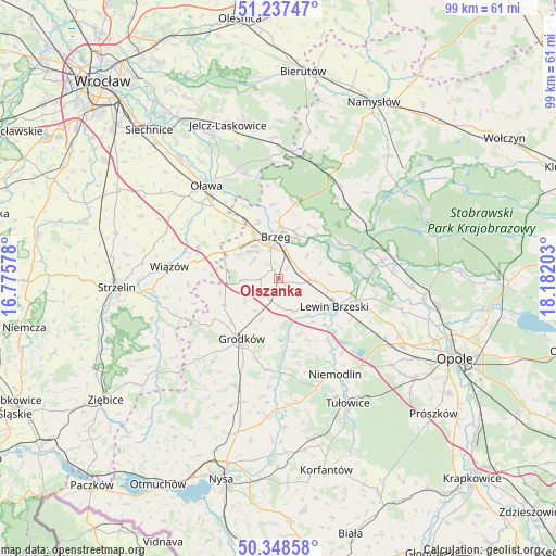
Olszanka GPS coordinates[2]
50° 47' 42.504" North, 17° 28' 44.04" East
| Map corner | latitude | longitude |
|---|---|---|
| Upper-left | 51.23747°, | 16.77578° |
| Center: | 50.79514°, | 17.4789° |
| Lower-right: | 50.34858°, | 18.18203° |
| Map W x H: | 98.8×98.8 km | = 61.4×61.4mi |
| max Lat: | 54.83135° ⇑60.3% North |
| Olszanka: | 50.79514° |
| min Lat: | ⇓39.7% South 49.21328° |
| min Long | Olszanka | max Long |
| 14.20249° | 17.4789° | 24.03723° |
| W 19.8%⇐ | ⇒80.2% E |
Elevation
Elevation of Olszanka is 159 m = 522 ft, and this is 32.4 m = 106 ft below average elevation for this country.
| Max E: |
974 m = 3196 ft | 54.9% |
| Avg. | 191.4 m = 628 ft | |
| Olszanka | 159 m = 522 ft | |
Min E: |
-3 m = -10 ft | 45.1% |
See also: Poland elevation on elevation.city.
Geographical zone
Olszanka is located in North temperate zone (between Tropic of Cancer and the Arctic Circle). Distance of this North polar circle is 1753.3 km =1089.4 mi to North.| Distance of | km | miles | from Olszanka |
|---|---|---|---|
| North Pole | 4359.2 | 2708.7 | to North |
| Arctic Circle | 1753.3 | 1089.4 | to North |
| Tropic Cancer | 3042 | 1890.2 | to South |
| Equator | 5647.9 | 3509.4 | to South |


Nearby cities:
15 places around Olszanka: (largest is in red/bold)
• Borkowice
17.7 km =11 mi,  109°
109°
• Brzeg
7.3 km =4.5 mi,  353°
353°
• Bystrzyca
19.3 km =12 mi,  342°
342°
• Grodków
12.6 km =7.8 mi,  211°
211°
• Krzyżowice
1.8 km =1.1 mi,  323°
323°
• Lewin Brzeski
11 km =6.8 mi,  118°
118°
• Lubsza
13.8 km =8.6 mi,  12°
12°
• Michałow
6 km =3.7 mi,  160°
160°
• Osiek
16.6 km =10.3 mi,  308°
308°
• Pogorzela
1.3 km =0.8 mi,  129°
129°
• Popielów
18.9 km =11.7 mi,  79°
79°
• Skarbimierz Osiedle
7 km =4.3 mi, 323°
• Skorogoszcz
14.8 km =9.2 mi, 105°
• Wiązów
19.6 km =12.2 mi,  276°
276°
• Łosiów
6.1 km =3.8 mi,  94°
94°
Sources, notices
• [Note1] Compared only with cities in Poland existing in our database
• [Src1] Map data: © OpenStreetMap contributors (CC-BY-SA)
• [Src2] Other city data from geonames.org with taken over terms of usage.
• [Src3] Geographical zone / Annual Mean Temperature by Robert A. Rohde @ Wikipedia
