Krzyżowice geodata
Krzyżowice (Opole Voivodeship) is a populated place; located in Poland in Europe/Warsaw (GMT+2) time zone. With population of 630 people, there are 3202 cities with bigger population in this country. Compared to other cities in Poland, 59.9% of cities are located further ↑North; 80.3% of cities are located further →East and 55.6% of cities have higher elevation than Krzyżowice. Note1


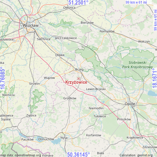
Krzyżowice GPS coordinates[2]
50° 48' 28.404" North, 17° 27' 50.292" East
| Map corner | latitude | longitude |
|---|---|---|
| Upper-left | 51.2501°, | 16.76085° |
| Center: | 50.80789°, | 17.46397° |
| Lower-right: | 50.36145°, | 18.1671° |
| Map W x H: | 98.8×98.8 km | = 61.4×61.4mi |
| max Lat: | 54.83135° ⇑59.9% North |
| Krzyżowice: | 50.80789° |
| min Lat: | ⇓40.1% South 49.21328° |
| min Long | Krzyżowice | max Long |
| 14.20249° | 17.46397° | 24.03723° |
| W 19.7%⇐ | ⇒80.3% E |
Elevation
Elevation of Krzyżowice is 157 m = 515 ft, and this is 34.4 m = 113 ft below average elevation for this country.
| Max E: |
974 m = 3196 ft | 55.6% |
| Avg. | 191.4 m = 628 ft | |
| Krzyżowice | 157 m = 515 ft | |
Min E: |
-3 m = -10 ft | 44.4% |
See also: Poland elevation on elevation.city.
Geographical zone
Krzyżowice is located in North temperate zone (between Tropic of Cancer and the Arctic Circle). Distance of this North polar circle is 1751.9 km =1088.6 mi to North.| Distance of | km | miles | from Krzyżowice |
|---|---|---|---|
| North Pole | 4357.8 | 2707.8 | to North |
| Arctic Circle | 1751.9 | 1088.6 | to North |
| Tropic Cancer | 3043.4 | 1891.1 | to South |
| Equator | 5649.3 | 3510.3 | to South |


Nearby cities:
15 places around Krzyżowice: (largest is in red/bold)
• Borkowice
19.2 km =11.9 mi,  112°
112°
• Brzeg
5.9 km =3.7 mi,  2°
2°
• Bystrzyca
17.6 km =10.9 mi,  344°
344°
• Grodków
13.4 km =8.3 mi,  204°
204°
• Lewin Brzeski
12.6 km =7.8 mi,  121°
121°
• Lubsza
12.7 km =7.9 mi,  18°
18°
• Michałow
7.7 km =4.8 mi,  156°
156°
• Olszanka
1.8 km =1.1 mi,  143°
143°
• Osiek
14.9 km =9.3 mi,  306°
306°
• Oława
19.6 km =12.2 mi,  322°
322°
• Pogorzela
3.1 km =1.9 mi, 137°
• Skarbimierz Osiedle
5.3 km =3.3 mi, 322°
• Skorogoszcz
16.3 km =10.1 mi, 109°
• Wiązów
18.4 km =11.4 mi,  272°
272°
• Łosiów
7.4 km =4.6 mi,  104°
104°
Sources, notices
• [Note1] Compared only with cities in Poland existing in our database
• [Src1] Map data: © OpenStreetMap contributors (CC-BY-SA)
• [Src2] Other city data from geonames.org with taken over terms of usage.
• [Src3] Geographical zone / Annual Mean Temperature by Robert A. Rohde @ Wikipedia
