Lniano geodata
Lniano (Kujawsko-Pomorskie) is a populated place; located in Poland in Europe/Warsaw (GMT+2) time zone. With population of 1,200 people, there are 2164 cities with bigger population in this country. Compared to other cities in Poland, 89.8% of cities are located further ↓South; 72.5% of cities are located further →East and 77.6% of cities have higher elevation than Lniano. Note1


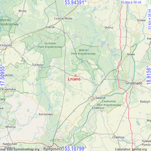
Lniano GPS coordinates[2]
53° 31' 40.836" North, 18° 12' 45.612" East
| Map corner | latitude | longitude |
|---|---|---|
| Upper-left | 53.94391°, | 17.50955° |
| Center: | 53.52801°, | 18.21267° |
| Lower-right: | 53.10799°, | 18.9158° |
| Map W x H: | 92.9×92.9 km | = 57.7×57.7mi |
| max Lat: | 54.83135° ⇑10.2% North |
| Lniano: | 53.52801° |
| min Lat: | ⇓89.8% South 49.21328° |
| min Long | Lniano | max Long |
| 14.20249° | 18.21267° | 24.03723° |
| W 27.5%⇐ | ⇒72.5% E |
Elevation
Elevation of Lniano is 104 m = 341 ft, and this is 87.4 m = 287 ft below average elevation for this country.
| Max E: |
974 m = 3196 ft | 77.6% |
| Avg. | 191.4 m = 628 ft | |
| Lniano | 104 m = 341 ft | |
Min E: |
-3 m = -10 ft | 22.4% |
See also: Poland elevation on elevation.city.
Geographical zone
Lniano is located in North temperate zone (between Tropic of Cancer and the Arctic Circle). Distance of this North polar circle is 1449.4 km =900.6 mi to North.| Distance of | km | miles | from Lniano |
|---|---|---|---|
| North Pole | 4055.3 | 2519.8 | to North |
| Arctic Circle | 1449.4 | 900.6 | to North |
| Tropic Cancer | 3345.8 | 2079 | to South |
| Equator | 5951.8 | 3698.3 | to South |


Nearby cities:
15 places around Lniano: (largest is in red/bold)
• Bukowiec
10.6 km =6.6 mi,  170°
170°
• Cekcyn
14.2 km =8.8 mi,  290°
290°
• Chełmno
24.4 km =15.2 mi,  144°
144°
• Drzycim
6.9 km =4.3 mi,  111°
111°
• Gostycyn
27 km =16.8 mi,  261°
261°
• Jeżewo
18.7 km =11.6 mi,  95°
95°
• Kamienica
27.2 km =16.9 mi, 258°
• Lubiewo
13.9 km =8.6 mi,  240°
240°
• Osie
11.7 km =7.3 mi,  47°
47°
• Osieczna
27.1 km =16.8 mi,  358°
358°
• Pruszcz
22 km =13.7 mi,  182°
182°
• Tuchola
24.3 km =15.1 mi, 285°
• Śliwice
20.3 km =12.6 mi,  352°
352°
• Świecie
20.4 km =12.7 mi,  130°
130°
• Świekatowo
14.4 km =8.9 mi,  212°
212°
Sources, notices
• [Note1] Compared only with cities in Poland existing in our database
• [Src1] Map data: © OpenStreetMap contributors (CC-BY-SA)
• [Src2] Other city data from geonames.org with taken over terms of usage.
• [Src3] Geographical zone / Annual Mean Temperature by Robert A. Rohde @ Wikipedia
