Gostycyn geodata
Gostycyn (Kujawsko-Pomorskie) is a seat of a third-order administrative division; located in Poland in Europe/Warsaw (GMT+2) time zone. With population of 1,800 people, there are 1605 cities with bigger population in this country. Compared to other cities in Poland, 89.5% of cities are located further ↓South; 77.1% of cities are located further →East and 75% of cities have higher elevation than Gostycyn. Note1


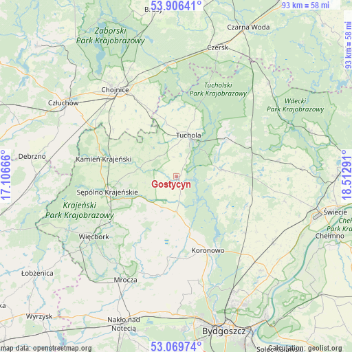
Gostycyn GPS coordinates[2]
53° 29' 24.504" North, 17° 48' 35.208" East
| Map corner | latitude | longitude |
|---|---|---|
| Upper-left | 53.90641°, | 17.10666° |
| Center: | 53.49014°, | 17.80978° |
| Lower-right: | 53.06974°, | 18.51291° |
| Map W x H: | 93×93 km | = 57.8×57.8mi |
| max Lat: | 54.83135° ⇑10.5% North |
| Gostycyn: | 53.49014° |
| min Lat: | ⇓89.5% South 49.21328° |
| min Long | Gostycyn | max Long |
| 14.20249° | 17.80978° | 24.03723° |
| W 22.9%⇐ | ⇒77.1% E |
Elevation
Elevation of Gostycyn is 111 m = 364 ft, and this is 80.4 m = 264 ft below average elevation for this country.
| Max E: |
974 m = 3196 ft | 75% |
| Avg. | 191.4 m = 628 ft | |
| Gostycyn | 111 m = 364 ft | |
Min E: |
-3 m = -10 ft | 25% |
See also: Poland elevation on elevation.city.
Geographical zone
Gostycyn is located in North temperate zone (between Tropic of Cancer and the Arctic Circle). Distance of this North polar circle is 1453.6 km =903.2 mi to North.| Distance of | km | miles | from Gostycyn |
|---|---|---|---|
| North Pole | 4059.5 | 2522.5 | to North |
| Arctic Circle | 1453.6 | 903.2 | to North |
| Tropic Cancer | 3341.6 | 2076.4 | to South |
| Equator | 5947.5 | 3695.6 | to South |


Nearby cities:
15 places around Gostycyn: (largest is in red/bold)
• Cekcyn
16.2 km =10.1 mi,  55°
55°
• Chojnice
28.3 km =17.6 mi,  323°
323°
• Kamienica
1.3 km =0.8 mi,  177°
177°
• Kamień Krajeński
19.7 km =12.2 mi,  284°
284°
• Koronowo
21.4 km =13.3 mi,  156°
156°
• Kęsowo
9.8 km =6.1 mi, 320°
• Lniano
27 km =16.8 mi,  81°
81°
• Lubiewo
14.8 km =9.2 mi,  100°
100°
• Ostrowite
18.5 km =11.5 mi,  329°
329°
• Raciąż
19.2 km =11.9 mi,  355°
355°
• Sośno
13.9 km =8.6 mi,  215°
215°
• Sępólno Krajeńskie
18.9 km =11.7 mi,  257°
257°
• Tuchola
11.3 km =7 mi,  16°
16°
• Więcbork
26 km =16.2 mi,  234°
234°
• Świekatowo
20.6 km =12.8 mi,  112°
112°
Sources, notices
• [Note1] Compared only with cities in Poland existing in our database
• [Src1] Map data: © OpenStreetMap contributors (CC-BY-SA)
• [Src2] Other city data from geonames.org with taken over terms of usage.
• [Src3] Geographical zone / Annual Mean Temperature by Robert A. Rohde @ Wikipedia
