Kamienica geodata
Kamienica (Kujawsko-Pomorskie) is a populated place; located in Poland in Europe/Warsaw (GMT+2) time zone. With population of 640 people, there are 3187 cities with bigger population in this country. Compared to other cities in Poland, 89.3% of cities are located further ↓South; 77.1% of cities are located further →East and 76.9% of cities have higher elevation than Kamienica. Note1


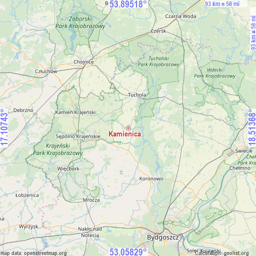
Kamienica GPS coordinates[2]
53° 28' 43.68" North, 17° 48' 37.98" East
| Map corner | latitude | longitude |
|---|---|---|
| Upper-left | 53.89518°, | 17.10743° |
| Center: | 53.4788°, | 17.81055° |
| Lower-right: | 53.05829°, | 18.51368° |
| Map W x H: | 93.1×93.1 km | = 57.8×57.8mi |
| max Lat: | 54.83135° ⇑10.7% North |
| Kamienica: | 53.4788° |
| min Lat: | ⇓89.3% South 49.21328° |
| min Long | Kamienica | max Long |
| 14.20249° | 17.81055° | 24.03723° |
| W 22.9%⇐ | ⇒77.1% E |
Elevation
Elevation of Kamienica is 106 m = 348 ft, and this is 85.4 m = 280 ft below average elevation for this country.
| Max E: |
974 m = 3196 ft | 76.9% |
| Avg. | 191.4 m = 628 ft | |
| Kamienica | 106 m = 348 ft | |
Min E: |
-3 m = -10 ft | 23.1% |
See also: Poland elevation on elevation.city.
Geographical zone
Kamienica is located in North temperate zone (between Tropic of Cancer and the Arctic Circle). Distance of this North polar circle is 1454.9 km =904 mi to North.| Distance of | km | miles | from Kamienica |
|---|---|---|---|
| North Pole | 4060.8 | 2523.3 | to North |
| Arctic Circle | 1454.9 | 904 | to North |
| Tropic Cancer | 3340.4 | 2075.6 | to South |
| Equator | 5946.3 | 3694.9 | to South |


Nearby cities:
15 places around Kamienica: (largest is in red/bold)
• Bukowiec
28.9 km =18 mi,  99°
99°
• Cekcyn
16.9 km =10.5 mi,  51°
51°
• Gostycyn
1.3 km =0.8 mi,  357°
357°
• Kamień Krajeński
20.1 km =12.5 mi,  287°
287°
• Koronowo
20.2 km =12.6 mi,  155°
155°
• Kęsowo
10.9 km =6.8 mi,  324°
324°
• Lniano
27.2 km =16.9 mi,  78°
78°
• Lubiewo
14.6 km =9.1 mi, 95°
• Ostrowite
19.6 km =12.2 mi,  331°
331°
• Raciąż
20.4 km =12.7 mi, 355°
• Sośno
12.9 km =8 mi,  219°
219°
• Sępólno Krajeńskie
18.7 km =11.6 mi,  260°
260°
• Tuchola
12.5 km =7.8 mi,  14°
14°
• Więcbork
25.3 km =15.7 mi,  236°
236°
• Świekatowo
20.1 km =12.5 mi,  109°
109°
Sources, notices
• [Note1] Compared only with cities in Poland existing in our database
• [Src1] Map data: © OpenStreetMap contributors (CC-BY-SA)
• [Src2] Other city data from geonames.org with taken over terms of usage.
• [Src3] Geographical zone / Annual Mean Temperature by Robert A. Rohde @ Wikipedia
