Dąbrówno geodata
Dąbrówno (Warmia-Masuria) is a seat of a third-order administrative division; located in Poland in Europe/Warsaw (GMT+2) time zone. With population of 1,400 people, there are 1959 cities with bigger population in this country. Compared to other cities in Poland, 88.9% of cities are located further ↓South; 58.9% of cities are located further ←West and 50.8% of cities have higher elevation than Dąbrówno. Note1


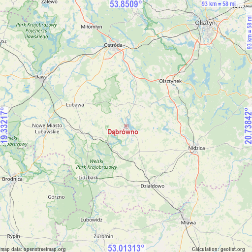
Dąbrówno GPS coordinates[2]
53° 26' 2.688" North, 20° 2' 7.044" East
| Map corner | latitude | longitude |
|---|---|---|
| Upper-left | 53.8509°, | 19.33217° |
| Center: | 53.43408°, | 20.03529° |
| Lower-right: | 53.01313°, | 20.73842° |
| Map W x H: | 93.2×93.1 km | = 57.9×57.8mi |
| max Lat: | 54.83135° ⇑11.1% North |
| Dąbrówno: | 53.43408° |
| min Lat: | ⇓88.9% South 49.21328° |
| min Long | Dąbrówno | max Long |
| 14.20249° | 20.03529° | 24.03723° |
| W 58.9%⇐ | ⇒41.1% E |
Elevation
Elevation of Dąbrówno is 170 m = 558 ft, and this is 21.4 m = 70 ft below average elevation for this country.
| Max E: |
974 m = 3196 ft | 50.8% |
| Avg. | 191.4 m = 628 ft | |
| Dąbrówno | 170 m = 558 ft | |
Min E: |
-3 m = -10 ft | 49.2% |
See also: Poland elevation on elevation.city.
Geographical zone
Dąbrówno is located in North temperate zone (between Tropic of Cancer and the Arctic Circle). Distance of this North polar circle is 1459.9 km =907.1 mi to North.| Distance of | km | miles | from Dąbrówno |
|---|---|---|---|
| North Pole | 4065.7 | 2526.3 | to North |
| Arctic Circle | 1459.9 | 907.1 | to North |
| Tropic Cancer | 3335.4 | 2072.5 | to South |
| Equator | 5941.3 | 3691.8 | to South |


Nearby cities:
15 places around Dąbrówno: (largest is in red/bold)
• Działdowo
23.4 km =14.5 mi,  157°
157°
• Gierzwałd
12.4 km =7.7 mi,  16°
16°
• Grabowo
20.2 km =12.6 mi,  314°
314°
• Grodziczno
18.3 km =11.4 mi,  262°
262°
• Grunwald
6.8 km =4.2 mi,  34°
34°
• Kozłowo
22.1 km =13.7 mi,  129°
129°
• Lidzbark
23.5 km =14.6 mi,  216°
216°
• Lubawa
20.5 km =12.7 mi,  292°
292°
• Mielno
13.7 km =8.5 mi,  49°
49°
• Nidzica
27.3 km =17 mi,  107°
107°
• Nowe Miasto Lubawskie
29.2 km =18.1 mi,  267°
267°
• Olsztynek
23.4 km =14.5 mi,  44°
44°
• Ostróda
29.6 km =18.4 mi,  350°
350°
• Płośnica
18.1 km =11.2 mi,  185°
185°
• Rybno
8.8 km =5.5 mi,  230°
230°
Sources, notices
• [Note1] Compared only with cities in Poland existing in our database
• [Src1] Map data: © OpenStreetMap contributors (CC-BY-SA)
• [Src2] Other city data from geonames.org with taken over terms of usage.
• [Src3] Geographical zone / Annual Mean Temperature by Robert A. Rohde @ Wikipedia
