Działdowo geodata
Działdowo (Warmia-Masuria) is a seat of a third-order administrative division; located in Poland in Europe/Warsaw (GMT+2) time zone. With population of 21,127 people, there are 233 cities with bigger population in this country. Compared to other cities in Poland, 86.8% of cities are located further ↓South; 60.9% of cities are located further ←West and 54.2% of cities have higher elevation than Działdowo. Note1


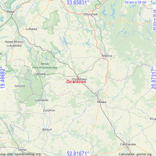
Działdowo GPS coordinates[2]
53° 14' 22.488" North, 20° 10' 12.144" East
| Map corner | latitude | longitude |
|---|---|---|
| Upper-left | 53.65831°, | 19.46692° |
| Center: | 53.23958°, | 20.17004° |
| Lower-right: | 52.81671°, | 20.87317° |
| Map W x H: | 93.6×93.6 km | = 58.2×58.2mi |
| max Lat: | 54.83135° ⇑13.2% North |
| Działdowo: | 53.23958° |
| min Lat: | ⇓86.8% South 49.21328° |
| min Long | Działdowo | max Long |
| 14.20249° | 20.17004° | 24.03723° |
| W 60.9%⇐ | ⇒39.1% E |
Elevation
Elevation of Działdowo is 161 m = 528 ft, and this is 30.4 m = 100 ft below average elevation for this country.
| Max E: |
974 m = 3196 ft | 54.2% |
| Avg. | 191.4 m = 628 ft | |
| Działdowo | 161 m = 528 ft | |
Min E: |
-3 m = -10 ft | 45.8% |
See also: Poland elevation on elevation.city.
Geographical zone
Działdowo is located in North temperate zone (between Tropic of Cancer and the Arctic Circle). Distance of this North polar circle is 1481.5 km =920.6 mi to North.| Distance of | km | miles | from Działdowo |
|---|---|---|---|
| North Pole | 4087.4 | 2539.8 | to North |
| Arctic Circle | 1481.5 | 920.6 | to North |
| Tropic Cancer | 3313.8 | 2059.1 | to South |
| Equator | 5919.7 | 3678.3 | to South |


Nearby cities:
15 places around Działdowo: (largest is in red/bold)
• Dąbrówno
23.4 km =14.5 mi,  337°
337°
• Iłowo -Osada
11.4 km =7.1 mi,  134°
134°
• Kozłowo
11 km =6.8 mi,  47°
47°
• Kuczbork-Osada
18.9 km =11.7 mi,  205°
205°
• Kuczbork-Wieś
19.3 km =12 mi, 205°
• Lidzbark
23 km =14.3 mi,  276°
276°
• Lipowiec Kościelny
15 km =9.3 mi,  178°
178°
• Lubowidz
25.4 km =15.8 mi,  238°
238°
• Mława
20.1 km =12.5 mi, 134°
• Nidzica
21.8 km =13.5 mi, 51°
• Płośnica
11.2 km =7 mi,  289°
289°
• Rybno
22.5 km =14 mi,  315°
315°
• Szreńsk
25.4 km =15.8 mi,  187°
187°
• Wieczfnia Kościelna
21 km =13 mi,  103°
103°
• Wiśniewo
22.8 km =14.2 mi,  148°
148°
Sources, notices
• [Note1] Compared only with cities in Poland existing in our database
• [Src1] Map data: © OpenStreetMap contributors (CC-BY-SA)
• [Src2] Other city data from geonames.org with taken over terms of usage.
• [Src3] Geographical zone / Annual Mean Temperature by Robert A. Rohde @ Wikipedia
