Grodziczno geodata
Grodziczno (Warmia-Masuria) is a populated place; located in Poland in Europe/Warsaw (GMT+2) time zone. With population of 890 people, there are 2695 cities with bigger population in this country. Compared to other cities in Poland, 88.7% of cities are located further ↓South; 53.9% of cities are located further ←West and 67.4% of cities have higher elevation than Grodziczno. Note1


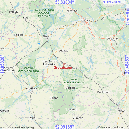
Grodziczno GPS coordinates[2]
53° 24' 46.836" North, 19° 45' 41.04" East
| Map corner | latitude | longitude |
|---|---|---|
| Upper-left | 53.83004°, | 19.05828° |
| Center: | 53.41301°, | 19.7614° |
| Lower-right: | 52.99185°, | 20.46453° |
| Map W x H: | 93.2×93.2 km | = 57.9×57.9mi |
| max Lat: | 54.83135° ⇑11.3% North |
| Grodziczno: | 53.41301° |
| min Lat: | ⇓88.7% South 49.21328° |
| min Long | Grodziczno | max Long |
| 14.20249° | 19.7614° | 24.03723° |
| W 53.9%⇐ | ⇒46.1% E |
Elevation
Elevation of Grodziczno is 127 m = 417 ft, and this is 64.4 m = 211 ft below average elevation for this country.
| Max E: |
974 m = 3196 ft | 67.4% |
| Avg. | 191.4 m = 628 ft | |
| Grodziczno | 127 m = 417 ft | |
Min E: |
-3 m = -10 ft | 32.6% |
See also: Poland elevation on elevation.city.
Geographical zone
Grodziczno is located in North temperate zone (between Tropic of Cancer and the Arctic Circle). Distance of this North polar circle is 1462.2 km =908.6 mi to North.| Distance of | km | miles | from Grodziczno |
|---|---|---|---|
| North Pole | 4068.1 | 2527.8 | to North |
| Arctic Circle | 1462.2 | 908.6 | to North |
| Tropic Cancer | 3333.1 | 2071.1 | to South |
| Equator | 5939 | 3690.3 | to South |


Nearby cities:
15 places around Grodziczno: (largest is in red/bold)
• Bartniczka
21.1 km =13.1 mi,  209°
209°
• Brzozie
14.2 km =8.8 mi,  226°
226°
• Brzozie Lubawskie
15.2 km =9.4 mi,  239°
239°
• Dąbrówno
18.3 km =11.4 mi,  82°
82°
• Gierzwałd
25.9 km =16.1 mi,  56°
56°
• Grabowo
17 km =10.6 mi,  13°
13°
• Grunwald
23.4 km =14.5 mi,  70°
70°
• Górzno
25.2 km =15.7 mi,  198°
198°
• Iława
24 km =14.9 mi,  327°
327°
• Kurzętnik
12.2 km =7.6 mi,  262°
262°
• Lidzbark
17.3 km =10.7 mi,  165°
165°
• Lubawa
10.2 km =6.3 mi,  355°
355°
• Nowe Miasto Lubawskie
11.1 km =6.9 mi,  274°
274°
• Płośnica
22.8 km =14.2 mi,  133°
133°
• Rybno
11.8 km =7.3 mi,  106°
106°
Sources, notices
• [Note1] Compared only with cities in Poland existing in our database
• [Src1] Map data: © OpenStreetMap contributors (CC-BY-SA)
• [Src2] Other city data from geonames.org with taken over terms of usage.
• [Src3] Geographical zone / Annual Mean Temperature by Robert A. Rohde @ Wikipedia
