Góra geodata
Góra (Pomerania) is a populated place; located in Poland in Europe/Warsaw (GMT+2) time zone. With population of 628 people, there are 3213 cities with bigger population in this country. Compared to other cities in Poland, 99.4% of cities are located further ↓South; 73.9% of cities are located further →East and 85.7% of cities have higher elevation than Góra. Note1


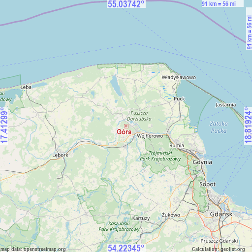
Góra GPS coordinates[2]
54° 37' 56.892" North, 18° 6' 57.996" East
| Map corner | latitude | longitude |
|---|---|---|
| Upper-left | 55.03742°, | 17.41299° |
| Center: | 54.63247°, | 18.11611° |
| Lower-right: | 54.22345°, | 18.81924° |
| Map W x H: | 90.5×90.5 km | = 56.2×56.2mi |
| max Lat: | 54.83135° ⇑0.6% North |
| Góra: | 54.63247° |
| min Lat: | ⇓99.4% South 49.21328° |
| min Long | Góra | max Long |
| 14.20249° | 18.11611° | 24.03723° |
| W 26.1%⇐ | ⇒73.9% E |
Elevation
Elevation of Góra is 88 m = 289 ft, and this is 103.4 m = 339 ft below average elevation for this country.
| Max E: |
974 m = 3196 ft | 85.7% |
| Avg. | 191.4 m = 628 ft | |
| Góra | 88 m = 289 ft | |
Min E: |
-3 m = -10 ft | 14.3% |
See also: Poland elevation on elevation.city.
Geographical zone
Góra is located in North temperate zone (between Tropic of Cancer and the Arctic Circle). Distance of this North polar circle is 1326.6 km =824.3 mi to North.| Distance of | km | miles | from Góra |
|---|---|---|---|
| North Pole | 3932.5 | 2443.5 | to North |
| Arctic Circle | 1326.6 | 824.3 | to North |
| Tropic Cancer | 3468.6 | 2155.3 | to South |
| Equator | 6074.6 | 3774.6 | to South |


Nearby cities:
15 places around Góra: (largest is in red/bold)
• Bolszewo
4.2 km =2.6 mi,  112°
112°
• Choczewo
18.7 km =11.6 mi,  309°
309°
• Gniewino
11.4 km =7.1 mi,  325°
325°
• Gościcino
4 km =2.5 mi,  141°
141°
• Krokowa
16.6 km =10.3 mi,  10°
10°
• Luzino
7.4 km =4.6 mi,  183°
183°
• Orle
3.6 km =2.2 mi,  76°
76°
• Reda
15.2 km =9.4 mi,  101°
101°
• Rekowo Dolne
15.9 km =9.9 mi,  90°
90°
• Rumia
18.8 km =11.7 mi, 111°
• Rybno
6 km =3.7 mi,  341°
341°
• Szemud
17.6 km =10.9 mi,  156°
156°
• Wejherowo
8.2 km =5.1 mi, 111°
• Wierzchucino
18.8 km =11.7 mi, 337°
• Łęczyce
17.1 km =10.6 mi,  255°
255°
Sources, notices
• [Note1] Compared only with cities in Poland existing in our database
• [Src1] Map data: © OpenStreetMap contributors (CC-BY-SA)
• [Src2] Other city data from geonames.org with taken over terms of usage.
• [Src3] Geographical zone / Annual Mean Temperature by Robert A. Rohde @ Wikipedia
