Rybno geodata
Rybno (Pomerania) is a populated place; located in Poland in Europe/Warsaw (GMT+2) time zone. With population of 510 people, there are 3513 cities with bigger population in this country. Compared to other cities in Poland, 99.6% of cities are located further ↓South; 74.3% of cities are located further →East and 93.1% of cities have higher elevation than Rybno. Note1


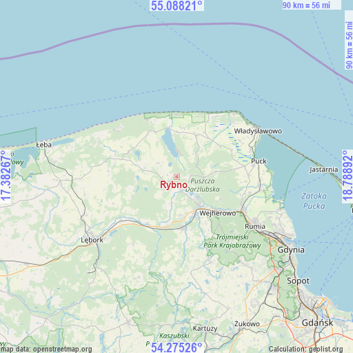
Rybno GPS coordinates[2]
54° 41' 1.572" North, 18° 5' 8.844" East
| Map corner | latitude | longitude |
|---|---|---|
| Upper-left | 55.08821°, | 17.38267° |
| Center: | 54.68377°, | 18.08579° |
| Lower-right: | 54.27526°, | 18.78892° |
| Map W x H: | 90.4×90.4 km | = 56.2×56.2mi |
| max Lat: | 54.83135° ⇑0.4% North |
| Rybno: | 54.68377° |
| min Lat: | ⇓99.6% South 49.21328° |
| min Long | Rybno | max Long |
| 14.20249° | 18.08579° | 24.03723° |
| W 25.7%⇐ | ⇒74.3% E |
Elevation
Elevation of Rybno is 59 m = 194 ft, and this is 132.4 m = 434 ft below average elevation for this country.
| Max E: |
974 m = 3196 ft | 93.1% |
| Avg. | 191.4 m = 628 ft | |
| Rybno | 59 m = 194 ft | |
Min E: |
-3 m = -10 ft | 6.9% |
See also: Poland elevation on elevation.city.
Geographical zone
Rybno is located in North temperate zone (between Tropic of Cancer and the Arctic Circle). Distance of this North polar circle is 1320.9 km =820.8 mi to North.| Distance of | km | miles | from Rybno |
|---|---|---|---|
| North Pole | 3926.8 | 2440 | to North |
| Arctic Circle | 1320.9 | 820.8 | to North |
| Tropic Cancer | 3474.3 | 2158.8 | to South |
| Equator | 6080.3 | 3778.1 | to South |


Nearby cities:
15 places around Rybno: (largest is in red/bold)
• Bolszewo
9.3 km =5.8 mi,  141°
141°
• Choczewo
13.9 km =8.6 mi,  296°
296°
• Gniewino
5.8 km =3.6 mi,  309°
309°
• Gościcino
9.9 km =6.2 mi,  153°
153°
• Góra
6 km =3.7 mi,  161°
161°
• Karwia
18 km =11.2 mi,  26°
26°
• Krokowa
11.7 km =7.3 mi,  24°
24°
• Luzino
13.2 km =8.2 mi,  173°
173°
• Orle
7.3 km =4.5 mi,  131°
131°
• Ostrowo
18.7 km =11.6 mi, 32°
• Reda
18.9 km =11.7 mi,  117°
117°
• Rekowo Dolne
18.7 km =11.6 mi,  108°
108°
• Wejherowo
13 km =8.1 mi, 132°
• Wierzchucino
12.7 km =7.9 mi,  335°
335°
• Łęczyce
17.7 km =11 mi,  235°
235°
Sources, notices
• [Note1] Compared only with cities in Poland existing in our database
• [Src1] Map data: © OpenStreetMap contributors (CC-BY-SA)
• [Src2] Other city data from geonames.org with taken over terms of usage.
• [Src3] Geographical zone / Annual Mean Temperature by Robert A. Rohde @ Wikipedia
