Sulęcin geodata
Sulęcin (Lesser Poland) is a seat of a second-order administrative division; located in Poland in Europe/Warsaw (GMT+2) time zone. With population of 10,090 people, there are 440 cities with bigger population in this country. Compared to other cities in Poland, 75.5% of cities are located further ↓South; 97.2% of cities are located further →East and 89.2% of cities have higher elevation than Sulęcin. Note1


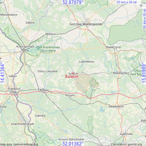
Sulęcin GPS coordinates[2]
52° 26' 39.444" North, 15° 7' 0.336" East
| Map corner | latitude | longitude |
|---|---|---|
| Upper-left | 52.87079°, | 14.41364° |
| Center: | 52.44429°, | 15.11676° |
| Lower-right: | 52.01362°, | 15.81989° |
| Map W x H: | 95.3×95.3 km | = 59.2×59.2mi |
| max Lat: | 54.83135° ⇑24.5% North |
| Sulęcin: | 52.44429° |
| min Lat: | ⇓75.5% South 49.21328° |
| min Long | Sulęcin | max Long |
| 14.20249° | 15.11676° | 24.03723° |
| W 2.8%⇐ | ⇒97.2% E |
Elevation
Elevation of Sulęcin is 78 m = 256 ft, and this is 113.4 m = 372 ft below average elevation for this country.
| Max E: |
974 m = 3196 ft | 89.2% |
| Avg. | 191.4 m = 628 ft | |
| Sulęcin | 78 m = 256 ft | |
Min E: |
-3 m = -10 ft | 10.8% |
See also: Poland elevation on elevation.city.
Geographical zone
Sulęcin is located in North temperate zone (between Tropic of Cancer and the Arctic Circle). Distance of this North polar circle is 1569.9 km =975.5 mi to North.| Distance of | km | miles | from Sulęcin |
|---|---|---|---|
| North Pole | 4175.8 | 2594.7 | to North |
| Arctic Circle | 1569.9 | 975.5 | to North |
| Tropic Cancer | 3225.3 | 2004.1 | to South |
| Equator | 5831.3 | 3623.4 | to South |


Nearby cities:
15 places around Sulęcin: (largest is in red/bold)
• Bledzew
21.7 km =13.5 mi,  68°
68°
• Boczów
17.8 km =11.1 mi,  220°
220°
• Bogdaniec
27.4 km =17 mi,  353°
353°
• Glisno
9.2 km =5.7 mi, 67°
• Krzeszyce
17.1 km =10.6 mi,  334°
334°
• Lemierzyce
19.3 km =12 mi,  314°
314°
• Lubniewice
12.1 km =7.5 mi,  48°
48°
• Lubrza
27.1 km =16.8 mi,  125°
125°
• Ośno Lubuskie
16.4 km =10.2 mi,  273°
273°
• Rzepin
22.2 km =13.8 mi,  240°
240°
• Sieniawa
19.9 km =12.4 mi,  116°
116°
• Słońsk
24.9 km =15.5 mi,  302°
302°
• Torzym
14.7 km =9.1 mi,  189°
189°
• Trzebiszewo
28 km =17.4 mi,  43°
43°
• Łagów
17.3 km =10.7 mi, 134°
Sources, notices
• [Note1] Compared only with cities in Poland existing in our database
• [Src1] Map data: © OpenStreetMap contributors (CC-BY-SA)
• [Src2] Other city data from geonames.org with taken over terms of usage.
• [Src3] Geographical zone / Annual Mean Temperature by Robert A. Rohde @ Wikipedia
