Chojnów geodata
Chojnów (Lower Silesia) is a seat of a third-order administrative division; located in Poland in Europe/Warsaw (GMT+2) time zone. With population of 14,209 people, there are 350 cities with bigger population in this country. Compared to other cities in Poland, 52.6% of cities are located further ↓South; 92.8% of cities are located further →East and 57.1% of cities have higher elevation than Chojnów. Note1


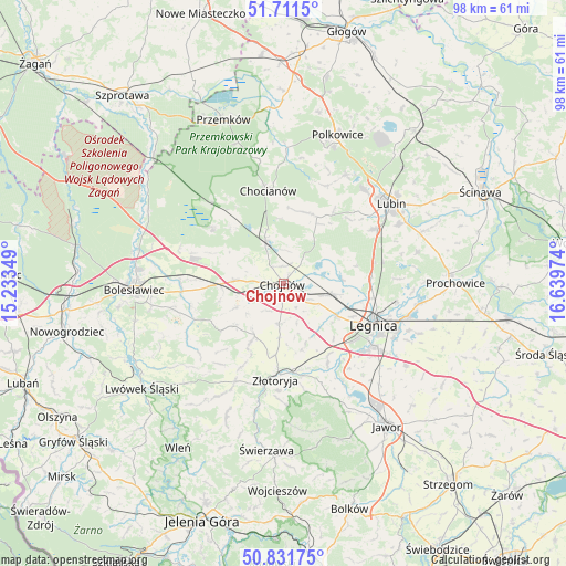
Chojnów GPS coordinates[2]
51° 16' 25.428" North, 15° 56' 11.796" East
| Map corner | latitude | longitude |
|---|---|---|
| Upper-left | 51.7115°, | 15.23349° |
| Center: | 51.27373°, | 15.93661° |
| Lower-right: | 50.83175°, | 16.63974° |
| Map W x H: | 97.8×97.8 km | = 60.8×60.8mi |
| max Lat: | 54.83135° ⇑47.4% North |
| Chojnów: | 51.27373° |
| min Lat: | ⇓52.6% South 49.21328° |
| min Long | Chojnów | max Long |
| 14.20249° | 15.93661° | 24.03723° |
| W 7.2%⇐ | ⇒92.8% E |
Elevation
Elevation of Chojnów is 153 m = 502 ft, and this is 38.4 m = 126 ft below average elevation for this country.
| Max E: |
974 m = 3196 ft | 57.1% |
| Avg. | 191.4 m = 628 ft | |
| Chojnów | 153 m = 502 ft | |
Min E: |
-3 m = -10 ft | 42.9% |
See also: Poland elevation on elevation.city.
Geographical zone
Chojnów is located in North temperate zone (between Tropic of Cancer and the Arctic Circle). Distance of this North polar circle is 1700.1 km =1056.4 mi to North.| Distance of | km | miles | from Chojnów |
|---|---|---|---|
| North Pole | 4306 | 2675.6 | to North |
| Arctic Circle | 1700.1 | 1056.4 | to North |
| Tropic Cancer | 3095.2 | 1923.3 | to South |
| Equator | 5701.1 | 3542.5 | to South |


Nearby cities:
15 places around Chojnów: (largest is in red/bold)
• Chocianów
16.3 km =10.1 mi,  351°
351°
• Gromadka
15.4 km =9.6 mi,  308°
308°
• Krotoszyce
16 km =9.9 mi,  151°
151°
• Krzywa
8.7 km =5.4 mi,  276°
276°
• Kunice
22.4 km =13.9 mi,  104°
104°
• Legnica
17.2 km =10.7 mi,  114°
114°
• Miłkowice
9.6 km =6 mi, 101°
• Olszanica
12.1 km =7.5 mi,  231°
231°
• Osiek
23.1 km =14.4 mi,  63°
63°
• Pielgrzymka
19.5 km =12.1 mi,  205°
205°
• Warta Bolesławiecka
19.3 km =12 mi,  255°
255°
• Wilków
20.2 km =12.6 mi,  181°
181°
• Zagrodno
10.4 km =6.5 mi, 208°
• Złotoryja
16.4 km =10.2 mi, 184°
• Łaziska
23.1 km =14.4 mi, 260°
Sources, notices
• [Note1] Compared only with cities in Poland existing in our database
• [Src1] Map data: © OpenStreetMap contributors (CC-BY-SA)
• [Src2] Other city data from geonames.org with taken over terms of usage.
• [Src3] Geographical zone / Annual Mean Temperature by Robert A. Rohde @ Wikipedia
