Krzywa geodata
Krzywa (Lower Silesia) is a populated place; located in Poland in Europe/Warsaw (GMT+2) time zone. With population of 560 people, there are 3377 cities with bigger population in this country. Compared to other cities in Poland, 52.8% of cities are located further ↓South; 93.5% of cities are located further →East and 55.2% of cities have lower elevation than Krzywa. Note1


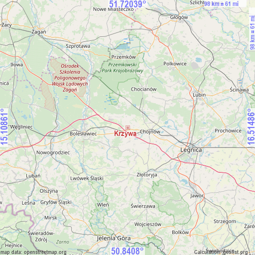
Krzywa GPS coordinates[2]
51° 16' 57.72" North, 15° 48' 42.228" East
| Map corner | latitude | longitude |
|---|---|---|
| Upper-left | 51.72039°, | 15.10861° |
| Center: | 51.2827°, | 15.81173° |
| Lower-right: | 50.8408°, | 16.51486° |
| Map W x H: | 97.8×97.8 km | = 60.8×60.8mi |
| max Lat: | 54.83135° ⇑47.2% North |
| Krzywa: | 51.2827° |
| min Lat: | ⇓52.8% South 49.21328° |
| min Long | Krzywa | max Long |
| 14.20249° | 15.81173° | 24.03723° |
| W 6.5%⇐ | ⇒93.5% E |
Elevation
Elevation of Krzywa is 186 m = 610 ft, and this is 5.4 m = 18 ft below average elevation for this country.
| Max E: |
974 m = 3196 ft | 44.8% |
| Avg. | 191.4 m = 628 ft | |
| Krzywa | 186 m = 610 ft | |
Min E: |
-3 m = -10 ft | 55.2% |
See also: Poland elevation on elevation.city.
Geographical zone
Krzywa is located in North temperate zone (between Tropic of Cancer and the Arctic Circle). Distance of this North polar circle is 1699.1 km =1055.8 mi to North.| Distance of | km | miles | from Krzywa |
|---|---|---|---|
| North Pole | 4305 | 2675 | to North |
| Arctic Circle | 1699.1 | 1055.8 | to North |
| Tropic Cancer | 3096.2 | 1923.9 | to South |
| Equator | 5702.1 | 3543.1 | to South |


Nearby cities:
15 places around Krzywa: (largest is in red/bold)
• Bolesławiec
17 km =10.6 mi,  263°
263°
• Chocianów
16.4 km =10.2 mi,  22°
22°
• Chojnów
8.7 km =5.4 mi,  96°
96°
• Gromadka
9.3 km =5.8 mi,  339°
339°
• Krotoszyce
22.2 km =13.8 mi,  132°
132°
• Legnica
25.7 km =16 mi,  108°
108°
• Lwówek Śląski
24.8 km =15.4 mi,  219°
219°
• Miłkowice
18.4 km =11.4 mi, 99°
• Olszanica
8.5 km =5.3 mi,  185°
185°
• Pielgrzymka
18.6 km =11.6 mi,  179°
179°
• Warta Bolesławiecka
11.5 km =7.1 mi,  240°
240°
• Wilków
22.7 km =14.1 mi,  159°
159°
• Zagrodno
10.8 km =6.7 mi, 159°
• Złotoryja
18.9 km =11.7 mi, 156°
• Łaziska
14.9 km =9.3 mi,  251°
251°
Sources, notices
• [Note1] Compared only with cities in Poland existing in our database
• [Src1] Map data: © OpenStreetMap contributors (CC-BY-SA)
• [Src2] Other city data from geonames.org with taken over terms of usage.
• [Src3] Geographical zone / Annual Mean Temperature by Robert A. Rohde @ Wikipedia
