Zagrodno geodata
Zagrodno (Lower Silesia) is a seat of a third-order administrative division; located in Poland in Europe/Warsaw (GMT+2) time zone. With population of 1,626 people, there are 1735 cities with bigger population in this country. Compared to other cities in Poland, 50.7% of cities are located further ↓South; 93.3% of cities are located further →East and 53.8% of cities have lower elevation than Zagrodno. Note1


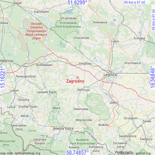
Zagrodno GPS coordinates[2]
51° 11' 28.824" North, 15° 51' 55.188" East
| Map corner | latitude | longitude |
|---|---|---|
| Upper-left | 51.6299°, | 15.16221° |
| Center: | 51.19134°, | 15.86533° |
| Lower-right: | 50.74857°, | 16.56846° |
| Map W x H: | 98×98 km | = 60.9×60.9mi |
| max Lat: | 54.83135° ⇑49.3% North |
| Zagrodno: | 51.19134° |
| min Lat: | ⇓50.7% South 49.21328° |
| min Long | Zagrodno | max Long |
| 14.20249° | 15.86533° | 24.03723° |
| W 6.7%⇐ | ⇒93.3% E |
Elevation
Elevation of Zagrodno is 182 m = 597 ft, and this is 9.4 m = 31 ft below average elevation for this country.
| Max E: |
974 m = 3196 ft | 46.2% |
| Avg. | 191.4 m = 628 ft | |
| Zagrodno | 182 m = 597 ft | |
Min E: |
-3 m = -10 ft | 53.8% |
See also: Poland elevation on elevation.city.
Geographical zone
Zagrodno is located in North temperate zone (between Tropic of Cancer and the Arctic Circle). Distance of this North polar circle is 1709.2 km =1062 mi to North.| Distance of | km | miles | from Zagrodno |
|---|---|---|---|
| North Pole | 4315.1 | 2681.3 | to North |
| Arctic Circle | 1709.2 | 1062 | to North |
| Tropic Cancer | 3086 | 1917.6 | to South |
| Equator | 5691.9 | 3536.8 | to South |


Nearby cities:
15 places around Zagrodno: (largest is in red/bold)
• Chojnów
10.4 km =6.5 mi,  28°
28°
• Gromadka
20.1 km =12.5 mi,  339°
339°
• Krotoszyce
13.5 km =8.4 mi,  111°
111°
• Krzywa
10.8 km =6.7 mi, 339°
• Legnica
20.8 km =12.9 mi,  84°
84°
• Miłkowice
16.1 km =10 mi,  63°
63°
• Męcinka
20.8 km =12.9 mi,  129°
129°
• Olszanica
4.8 km =3 mi,  290°
290°
• Pielgrzymka
9.1 km =5.7 mi,  203°
203°
• Sędziszowa
18.4 km =11.4 mi,  177°
177°
• Warta Bolesławiecka
14.5 km =9 mi, 287°
• Wilków
11.9 km =7.4 mi,  158°
158°
• Złotoryja
8.2 km =5.1 mi,  152°
152°
• Łaziska
18.7 km =11.6 mi, 286°
• Świerzawa
19.9 km =12.4 mi,  173°
173°
Sources, notices
• [Note1] Compared only with cities in Poland existing in our database
• [Src1] Map data: © OpenStreetMap contributors (CC-BY-SA)
• [Src2] Other city data from geonames.org with taken over terms of usage.
• [Src3] Geographical zone / Annual Mean Temperature by Robert A. Rohde @ Wikipedia
