Lądek-Zdrój geodata
Lądek-Zdrój (Lower Silesia) is a seat of a third-order administrative division; located in Poland in Europe/Warsaw (GMT+2) time zone. With population of 6,140 people, there are 592 cities with bigger population in this country. Compared to other cities in Poland, 70.9% of cities are located further ↑North; 86.3% of cities are located further →East and 95.7% of cities have lower elevation than Lądek-Zdrój. Note1


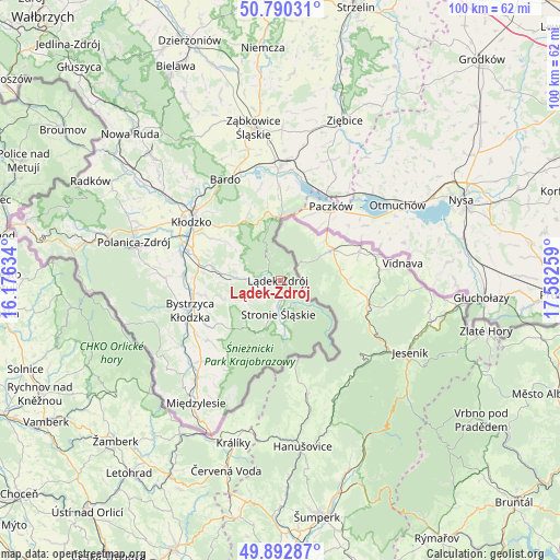
Lądek-Zdrój GPS coordinates[2]
50° 20' 37.356" North, 16° 52' 46.056" East
| Map corner | latitude | longitude |
|---|---|---|
| Upper-left | 50.79031°, | 16.17634° |
| Center: | 50.34371°, | 16.87946° |
| Lower-right: | 49.89287°, | 17.58259° |
| Map W x H: | 99.8×99.8 km | = 62×62mi |
| max Lat: | 54.83135° ⇑70.9% North |
| Lądek-Zdrój: | 50.34371° |
| min Lat: | ⇓29.1% South 49.21328° |
| min Long | Lądek-Zdrój | max Long |
| 14.20249° | 16.87946° | 24.03723° |
| W 13.7%⇐ | ⇒86.3% E |
Elevation
Elevation of Lądek-Zdrój is 434 m = 1424 ft, and this is 242.6 m = 796 ft above average elevation for this country.
| Max E: |
974 m = 3196 ft | 4.3% |
| Lądek-Zdrój | 434 m 1424 ft | |
| Avg. | 191.4 m = 628 ft | |
Min E: |
-3 m = -10 ft | 95.7% |
See also: Poland elevation on elevation.city.
Geographical zone
Lądek-Zdrój is located in North temperate zone (between Tropic of Cancer and the Arctic Circle). Distance of this North polar circle is 1803.5 km =1120.6 mi to North.| Distance of | km | miles | from Lądek-Zdrój |
|---|---|---|---|
| North Pole | 4409.4 | 2739.9 | to North |
| Arctic Circle | 1803.5 | 1120.6 | to North |
| Tropic Cancer | 2991.8 | 1859 | to South |
| Equator | 5597.7 | 3478.2 | to South |


Nearby cities:
15 places around Lądek-Zdrój: (largest is in red/bold)
• Bardo
20.6 km =12.8 mi,  331°
331°
• Bierkowice
24.4 km =15.2 mi,  306°
306°
• Brzeźnica
24.2 km =15 mi, 334°
• Bystrzyca Kłodzka
17.5 km =10.9 mi,  254°
254°
• Kamienica
13 km =8.1 mi,  24°
24°
• Kamieniec Ząbkowicki
20.2 km =12.6 mi,  359°
359°
• Kłodzko
18.5 km =11.5 mi,  303°
303°
• Maciejowice
25.4 km =15.8 mi,  46°
46°
• Niedźwiedź
23.3 km =14.5 mi, 21°
• Otmuchów
24.9 km =15.5 mi,  56°
56°
• Paczków
16.1 km =10 mi,  33°
33°
• Przyłęk
20.8 km =12.9 mi,  339°
339°
• Stronie Śląskie
5.4 km =3.4 mi,  184°
184°
• Wojciechowice
17.4 km =10.8 mi, 314°
• Złoty Stok
11.2 km =7 mi, 358°
Sources, notices
• [Note1] Compared only with cities in Poland existing in our database
• [Src1] Map data: © OpenStreetMap contributors (CC-BY-SA)
• [Src2] Other city data from geonames.org with taken over terms of usage.
• [Src3] Geographical zone / Annual Mean Temperature by Robert A. Rohde @ Wikipedia
