Niedźwiedź geodata
Niedźwiedź (Lower Silesia) is a populated place; located in Poland in Europe/Warsaw (GMT+2) time zone. With population of 647 people, there are 3175 cities with bigger population in this country. Compared to other cities in Poland, 66.5% of cities are located further ↑North; 84.7% of cities are located further →East and 86.4% of cities have lower elevation than Niedźwiedź. Note1


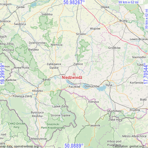
Niedźwiedź GPS coordinates[2]
50° 32' 16.44" North, 17° 0' 8.316" East
| Map corner | latitude | longitude |
|---|---|---|
| Upper-left | 50.98267°, | 16.29919° |
| Center: | 50.5379°, | 17.00231° |
| Lower-right: | 50.0889°, | 17.70544° |
| Map W x H: | 99.4×99.4 km | = 61.8×61.8mi |
| max Lat: | 54.83135° ⇑66.5% North |
| Niedźwiedź: | 50.5379° |
| min Lat: | ⇓33.5% South 49.21328° |
| min Long | Niedźwiedź | max Long |
| 14.20249° | 17.00231° | 24.03723° |
| W 15.3%⇐ | ⇒84.7% E |
Elevation
Elevation of Niedźwiedź is 298 m = 978 ft, and this is 106.6 m = 350 ft above average elevation for this country.
| Max E: |
974 m = 3196 ft | 13.6% |
| Niedźwiedź | 298 m 978 ft | |
| Avg. | 191.4 m = 628 ft | |
Min E: |
-3 m = -10 ft | 86.4% |
See also: Poland elevation on elevation.city.
Geographical zone
Niedźwiedź is located in North temperate zone (between Tropic of Cancer and the Arctic Circle). Distance of this North polar circle is 1781.9 km =1107.2 mi to North.| Distance of | km | miles | from Niedźwiedź |
|---|---|---|---|
| North Pole | 4387.8 | 2726.5 | to North |
| Arctic Circle | 1781.9 | 1107.2 | to North |
| Tropic Cancer | 3013.4 | 1872.4 | to South |
| Equator | 5619.3 | 3491.7 | to South |


Nearby cities:
15 places around Niedźwiedź: (largest is in red/bold)
• Bardo
18.9 km =11.7 mi,  259°
259°
• Bobolice
13.9 km =8.6 mi,  312°
312°
• Ciepłowody
16.6 km =10.3 mi,  336°
336°
• Henryków
12.8 km =8 mi,  2°
2°
• Kamienica
10.3 km =6.4 mi,  199°
199°
• Kamieniec Ząbkowicki
8.8 km =5.5 mi, 260°
• Kamiennik
11 km =6.8 mi,  70°
70°
• Maciejowice
10.4 km =6.5 mi,  112°
112°
• Otmuchów
14.5 km =9 mi,  123°
123°
• Paczków
8.2 km =5.1 mi,  177°
177°
• Przyłęk
16 km =9.9 mi, 262°
• Tarnów
15.6 km =9.7 mi,  286°
286°
• Ziębice
7.5 km =4.7 mi,  21°
21°
• Ząbkowice Śląskie
14.6 km =9.1 mi, 293°
• Złoty Stok
13.7 km =8.5 mi,  220°
220°
Sources, notices
• [Note1] Compared only with cities in Poland existing in our database
• [Src1] Map data: © OpenStreetMap contributors (CC-BY-SA)
• [Src2] Other city data from geonames.org with taken over terms of usage.
• [Src3] Geographical zone / Annual Mean Temperature by Robert A. Rohde @ Wikipedia
