Złoty Stok geodata
Złoty Stok (Lower Silesia) is a populated place; located in Poland in Europe/Warsaw (GMT+2) time zone. With population of 2,925 people, there are 1081 cities with bigger population in this country. Compared to other cities in Poland, 68.4% of cities are located further ↑North; 86.4% of cities are located further →East and 91.5% of cities have lower elevation than Złoty Stok. Note1


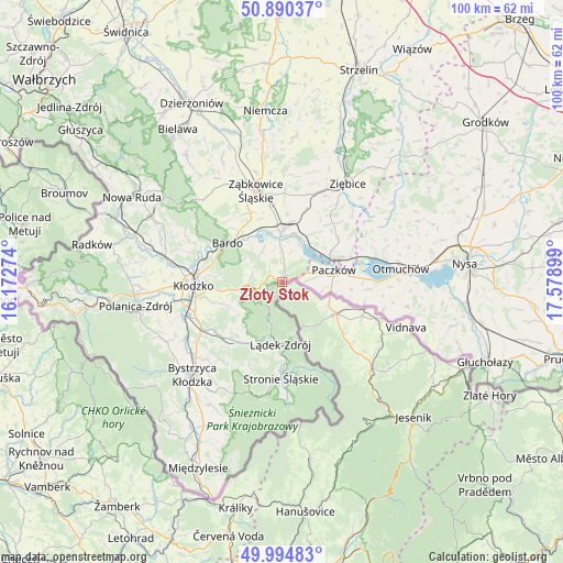
Złoty Stok GPS coordinates[2]
50° 26' 40.992" North, 16° 52' 33.096" East
| Map corner | latitude | longitude |
|---|---|---|
| Upper-left | 50.89037°, | 16.17274° |
| Center: | 50.44472°, | 16.87586° |
| Lower-right: | 49.99483°, | 17.57899° |
| Map W x H: | 99.6×99.6 km | = 61.9×61.9mi |
| max Lat: | 54.83135° ⇑68.4% North |
| Złoty Stok: | 50.44472° |
| min Lat: | ⇓31.6% South 49.21328° |
| min Long | Złoty Stok | max Long |
| 14.20249° | 16.87586° | 24.03723° |
| W 13.6%⇐ | ⇒86.4% E |
Elevation
Elevation of Złoty Stok is 350 m = 1148 ft, and this is 158.6 m = 520 ft above average elevation for this country.
| Max E: |
974 m = 3196 ft | 8.5% |
| Złoty Stok | 350 m 1148 ft | |
| Avg. | 191.4 m = 628 ft | |
Min E: |
-3 m = -10 ft | 91.5% |
See also: Poland elevation on elevation.city.
Geographical zone
Złoty Stok is located in North temperate zone (between Tropic of Cancer and the Arctic Circle). Distance of this North polar circle is 1792.2 km =1113.6 mi to North.| Distance of | km | miles | from Złoty Stok |
|---|---|---|---|
| North Pole | 4398.1 | 2732.9 | to North |
| Arctic Circle | 1792.2 | 1113.6 | to North |
| Tropic Cancer | 3003 | 1866 | to South |
| Equator | 5608.9 | 3485.2 | to South |


Nearby cities:
15 places around Złoty Stok: (largest is in red/bold)
• Bardo
11.8 km =7.3 mi,  305°
305°
• Bierkowice
19.6 km =12.2 mi,  279°
279°
• Brzeźnica
14.7 km =9.1 mi,  316°
316°
• Kamienica
5.6 km =3.5 mi,  83°
83°
• Kamieniec Ząbkowicki
9 km =5.6 mi,  1°
1°
• Kłodzko
15.2 km =9.4 mi,  265°
265°
• Lądek-Zdrój
11.2 km =7 mi,  178°
178°
• Maciejowice
19.6 km =12.2 mi,  71°
71°
• Niedźwiedź
13.7 km =8.5 mi,  40°
40°
• Paczków
9.5 km =5.9 mi, 76°
• Przyłęk
10.8 km =6.7 mi, 320°
• Stronie Śląskie
16.6 km =10.3 mi, 180°
• Tarnów
16.1 km =10 mi,  337°
337°
• Wojciechowice
12.1 km =7.5 mi, 274°
• Ząbkowice Śląskie
16.7 km =10.4 mi, 344°
Sources, notices
• [Note1] Compared only with cities in Poland existing in our database
• [Src1] Map data: © OpenStreetMap contributors (CC-BY-SA)
• [Src2] Other city data from geonames.org with taken over terms of usage.
• [Src3] Geographical zone / Annual Mean Temperature by Robert A. Rohde @ Wikipedia
