Kamienica geodata
Kamienica (Opole Voivodeship) is a populated place; located in Poland in Europe/Warsaw (GMT+2) time zone. With population of 1,300 people, there are 2055 cities with bigger population in this country. Compared to other cities in Poland, 68.2% of cities are located further ↑North; 85.5% of cities are located further →East and 79% of cities have lower elevation than Kamienica. Note1


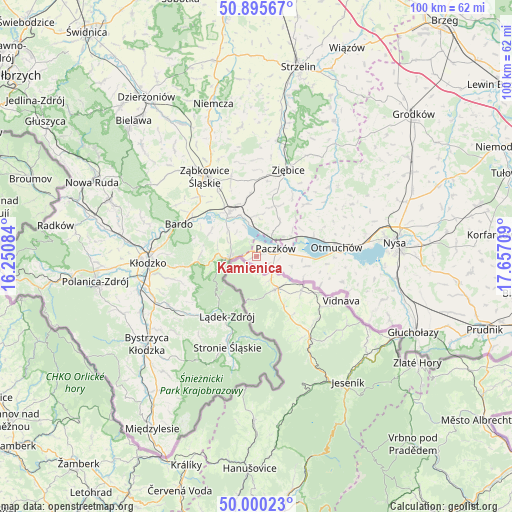
Kamienica GPS coordinates[2]
50° 27' 0.252" North, 16° 57' 14.256" East
| Map corner | latitude | longitude |
|---|---|---|
| Upper-left | 50.89567°, | 16.25084° |
| Center: | 50.45007°, | 16.95396° |
| Lower-right: | 50.00023°, | 17.65709° |
| Map W x H: | 99.6×99.6 km | = 61.9×61.9mi |
| max Lat: | 54.83135° ⇑68.2% North |
| Kamienica: | 50.45007° |
| min Lat: | ⇓31.8% South 49.21328° |
| min Long | Kamienica | max Long |
| 14.20249° | 16.95396° | 24.03723° |
| W 14.5%⇐ | ⇒85.5% E |
Elevation
Elevation of Kamienica is 261 m = 856 ft, and this is 69.6 m = 228 ft above average elevation for this country.
| Max E: |
974 m = 3196 ft | 21% |
| Kamienica | 261 m 856 ft | |
| Avg. | 191.4 m = 628 ft | |
Min E: |
-3 m = -10 ft | 79% |
See also: Poland elevation on elevation.city.
Geographical zone
Kamienica is located in North temperate zone (between Tropic of Cancer and the Arctic Circle). Distance of this North polar circle is 1791.7 km =1113.3 mi to North.| Distance of | km | miles | from Kamienica |
|---|---|---|---|
| North Pole | 4397.5 | 2732.5 | to North |
| Arctic Circle | 1791.7 | 1113.3 | to North |
| Tropic Cancer | 3003.6 | 1866.3 | to South |
| Equator | 5609.5 | 3485.6 | to South |


Nearby cities:
15 places around Kamienica: (largest is in red/bold)
• Bardo
16.4 km =10.2 mi,  292°
292°
• Brzeźnica
18.6 km =11.6 mi,  302°
302°
• Kamieniec Ząbkowicki
9.9 km =6.2 mi,  327°
327°
• Lądek-Zdrój
13 km =8.1 mi,  204°
204°
• Maciejowice
14.2 km =8.8 mi,  66°
66°
• Niedźwiedź
10.3 km =6.4 mi,  19°
19°
• Otmuchów
15.6 km =9.7 mi,  83°
83°
• Paczków
4 km =2.5 mi, 67°
• Przyłęk
14.6 km =9.1 mi, 301°
• Stronie Śląskie
18.1 km =11.2 mi, 198°
• Tarnów
18.4 km =11.4 mi,  320°
320°
• Wojciechowice
17.6 km =10.9 mi,  271°
271°
• Ziębice
17.9 km =11.1 mi, 20°
• Ząbkowice Śląskie
18.5 km =11.5 mi, 327°
• Złoty Stok
5.6 km =3.5 mi,  263°
263°
Sources, notices
• [Note1] Compared only with cities in Poland existing in our database
• [Src1] Map data: © OpenStreetMap contributors (CC-BY-SA)
• [Src2] Other city data from geonames.org with taken over terms of usage.
• [Src3] Geographical zone / Annual Mean Temperature by Robert A. Rohde @ Wikipedia
