Paczków geodata
Paczków (Opole Voivodeship) is a seat of a third-order administrative division; located in Poland in Europe/Warsaw (GMT+2) time zone. With population of 8,081 people, there are 505 cities with bigger population in this country. Compared to other cities in Poland, 68% of cities are located further ↑North; 84.7% of cities are located further →East and 69.8% of cities have lower elevation than Paczków. Note1


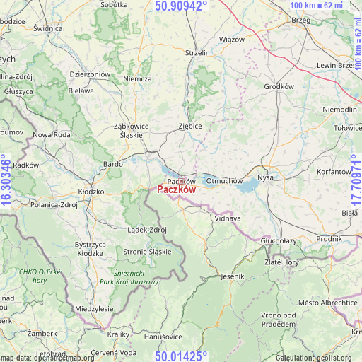
Paczków GPS coordinates[2]
50° 27' 50.22" North, 17° 0' 23.688" East
| Map corner | latitude | longitude |
|---|---|---|
| Upper-left | 50.90942°, | 16.30346° |
| Center: | 50.46395°, | 17.00658° |
| Lower-right: | 50.01425°, | 17.70971° |
| Map W x H: | 99.5×99.5 km | = 61.8×61.8mi |
| max Lat: | 54.83135° ⇑68% North |
| Paczków: | 50.46395° |
| min Lat: | ⇓32% South 49.21328° |
| min Long | Paczków | max Long |
| 14.20249° | 17.00658° | 24.03723° |
| W 15.3%⇐ | ⇒84.7% E |
Elevation
Elevation of Paczków is 229 m = 751 ft, and this is 37.6 m = 123 ft above average elevation for this country.
| Max E: |
974 m = 3196 ft | 30.2% |
| Paczków | 229 m 751 ft | |
| Avg. | 191.4 m = 628 ft | |
Min E: |
-3 m = -10 ft | 69.8% |
See also: Poland elevation on elevation.city.
Geographical zone
Paczków is located in North temperate zone (between Tropic of Cancer and the Arctic Circle). Distance of this North polar circle is 1790.1 km =1112.3 mi to North.| Distance of | km | miles | from Paczków |
|---|---|---|---|
| North Pole | 4396 | 2731.5 | to North |
| Arctic Circle | 1790.1 | 1112.3 | to North |
| Tropic Cancer | 3005.1 | 1867.3 | to South |
| Equator | 5611.1 | 3486.6 | to South |


Nearby cities:
15 places around Paczków: (largest is in red/bold)
• Bardo
19.4 km =12.1 mi,  283°
283°
• Bobolice
20.5 km =12.7 mi,  329°
329°
• Kamienica
4 km =2.5 mi,  247°
247°
• Kamieniec Ząbkowicki
11.3 km =7 mi,  307°
307°
• Kamiennik
15.6 km =9.7 mi,  40°
40°
• Lądek-Zdrój
16.1 km =10 mi,  213°
213°
• Maciejowice
10.2 km =6.3 mi,  65°
65°
• Niedźwiedź
8.2 km =5.1 mi,  357°
357°
• Otmuchów
11.8 km =7.3 mi,  88°
88°
• Przyłęk
17.3 km =10.7 mi,  290°
290°
• Stronie Śląskie
21 km =13 mi, 206°
• Tarnów
19.9 km =12.4 mi, 309°
• Ziębice
15.5 km =9.6 mi,  8°
8°
• Ząbkowice Śląskie
19.6 km =12.2 mi,  315°
315°
• Złoty Stok
9.5 km =5.9 mi,  256°
256°
Sources, notices
• [Note1] Compared only with cities in Poland existing in our database
• [Src1] Map data: © OpenStreetMap contributors (CC-BY-SA)
• [Src2] Other city data from geonames.org with taken over terms of usage.
• [Src3] Geographical zone / Annual Mean Temperature by Robert A. Rohde @ Wikipedia
