Chróścice geodata
Chróścice (Opole Voivodeship) is a populated place; located in Poland in Europe/Warsaw (GMT+2) time zone. With population of 3,000 people, there are 1040 cities with bigger population in this country. Compared to other cities in Poland, 60.6% of cities are located further ↑North; 77% of cities are located further →East and 60.3% of cities have higher elevation than Chróścice. Note1
Administrative division(s):
- Level 1: Opole Voivodeship
- Level 2: Powiat opolski
- Level 3: Dobrzeń Wielki


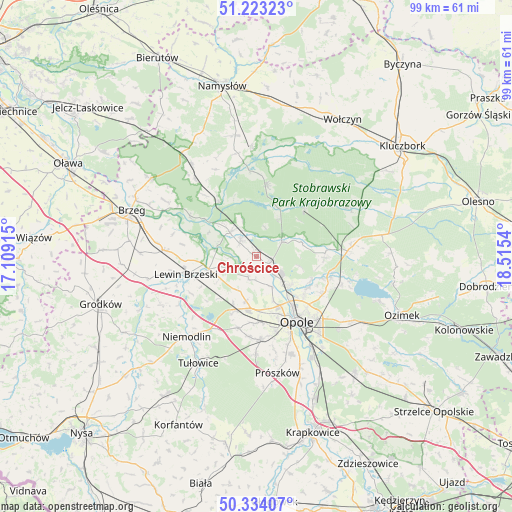
Chróścice GPS coordinates[2]
50° 46' 50.736" North, 17° 48' 44.172" East
| Map corner | latitude | longitude |
|---|---|---|
| Upper-left | 51.22323°, | 17.10915° |
| Center: | 50.78076°, | 17.81227° |
| Lower-right: | 50.33407°, | 18.5154° |
| Map W x H: | 98.9×98.9 km | = 61.5×61.5mi |
| max Lat: | 54.83135° ⇑60.6% North |
| Chróścice: | 50.78076° |
| min Lat: | ⇓39.4% South 49.21328° |
| min Long | Chróścice | max Long |
| 14.20249° | 17.81227° | 24.03723° |
| W 23%⇐ | ⇒77% E |
Elevation
Elevation of Chróścice is 146 m = 479 ft, and this is 45.4 m = 149 ft below average elevation for this country.
| Max E: |
974 m = 3196 ft | 60.3% |
| Avg. | 191.4 m = 628 ft | |
| Chróścice | 146 m = 479 ft | |
Min E: |
-3 m = -10 ft | 39.7% |
See also: Poland elevation on elevation.city.
Geographical zone
Chróścice is located in North temperate zone (between Tropic of Cancer and the Arctic Circle). Distance of this North polar circle is 1754.9 km =1090.4 mi to North.| Distance of | km | miles | from Chróścice |
|---|---|---|---|
| North Pole | 4360.8 | 2709.7 | to North |
| Arctic Circle | 1754.9 | 1090.4 | to North |
| Tropic Cancer | 3040.4 | 1889.2 | to South |
| Equator | 5646.3 | 3508.4 | to South |


Nearby cities:
15 places around Chróścice: (largest is in red/bold)
• Borkowice
8.1 km =5 mi,  236°
236°
• Chrościna
12.8 km =8 mi,  178°
178°
• Czarnowąsy
8.4 km =5.2 mi,  133°
133°
• Dobrzeń Wielki
2.8 km =1.7 mi,  119°
119°
• Dąbrowa
11.7 km =7.3 mi,  202°
202°
• Karczów
8.8 km =5.5 mi,  192°
192°
• Kup
5.8 km =3.6 mi,  60°
60°
• Lewin Brzeski
14.2 km =8.8 mi,  255°
255°
• Murów
13.1 km =8.1 mi,  45°
45°
• Opole
14.5 km =9 mi,  146°
146°
• Pokój
13.7 km =8.5 mi,  7°
7°
• Popielów
7 km =4.3 mi,  316°
316°
• Skorogoszcz
9.5 km =5.9 mi, 255°
• Swierkle
8.5 km =5.3 mi,  102°
102°
• Łubniany
13.3 km =8.3 mi,  87°
87°
Sources, notices
• [Note1] Compared only with cities in Poland existing in our database
• [Src1] Map data: © OpenStreetMap contributors (CC-BY-SA)
• [Src2] Other city data from geonames.org with taken over terms of usage.
• [Src3] Geographical zone / Annual Mean Temperature by Robert A. Rohde @ Wikipedia
