Krzymów geodata
Krzymów (Greater Poland) is a seat of a third-order administrative division; located in Poland in Europe/Warsaw (GMT+2) time zone. In our database, there are 3649 cities with bigger population. Compared to other cities in Poland, 69.8% of cities are located further ↓South; 69.1% of cities are located further →East and 86.8% of cities have higher elevation than Krzymów. Note1


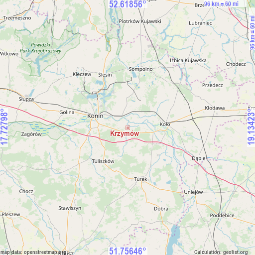
Krzymów GPS coordinates[2]
52° 11' 22.56" North, 18° 25' 51.96" East
| Map corner | latitude | longitude |
|---|---|---|
| Upper-left | 52.61856°, | 17.72798° |
| Center: | 52.1896°, | 18.4311° |
| Lower-right: | 51.75646°, | 19.13423° |
| Map W x H: | 95.9×95.9 km | = 59.6×59.6mi |
| max Lat: | 54.83135° ⇑30.2% North |
| Krzymów: | 52.1896° |
| min Lat: | ⇓69.8% South 49.21328° |
| min Long | Krzymów | max Long |
| 14.20249° | 18.4311° | 24.03723° |
| W 30.9%⇐ | ⇒69.1% E |
Elevation
Elevation of Krzymów is 85 m = 279 ft, and this is 106.4 m = 349 ft below average elevation for this country.
| Max E: |
974 m = 3196 ft | 86.8% |
| Avg. | 191.4 m = 628 ft | |
| Krzymów | 85 m = 279 ft | |
Min E: |
-3 m = -10 ft | 13.2% |
See also: Poland elevation on elevation.city.
Geographical zone
Krzymów is located in North temperate zone (between Tropic of Cancer and the Arctic Circle). Distance of this North polar circle is 1598.2 km =993.1 mi to North.| Distance of | km | miles | from Krzymów |
|---|---|---|---|
| North Pole | 4204.1 | 2612.3 | to North |
| Arctic Circle | 1598.2 | 993.1 | to North |
| Tropic Cancer | 3197 | 1986.5 | to South |
| Equator | 5802.9 | 3605.8 | to South |


Nearby cities:
15 places around Krzymów: (largest is in red/bold)
• Brudzew
15.5 km =9.6 mi,  130°
130°
• Konin
12.8 km =8 mi,  287°
287°
• Koło
14.2 km =8.8 mi,  85°
85°
• Kościelec
9.7 km =6 mi,  100°
100°
• Kramsk
8.4 km =5.2 mi,  356°
356°
• Licheń Stary
14.6 km =9.1 mi,  339°
339°
• Osiek Mały
15.1 km =9.4 mi,  50°
50°
• Paprotnia
1.8 km =1.1 mi,  202°
202°
• Police
19.7 km =12.2 mi,  7°
7°
• Russocice
9.2 km =5.7 mi,  158°
158°
• Stare Miasto
14.8 km =9.2 mi,  265°
265°
• Tarnowa
11.2 km =7 mi, 200°
• Tuliszków
15.6 km =9.7 mi,  216°
216°
• Turek
19.9 km =12.4 mi,  166°
166°
• Władysławów
10.1 km =6.3 mi, 162°
Sources, notices
• [Note1] Compared only with cities in Poland existing in our database
• [Src1] Map data: © OpenStreetMap contributors (CC-BY-SA)
• [Src2] Other city data from geonames.org with taken over terms of usage.
• [Src3] Geographical zone / Annual Mean Temperature by Robert A. Rohde @ Wikipedia
