Kościelec geodata
Kościelec (Greater Poland) is a seat of a third-order administrative division; located in Poland in Europe/Warsaw (GMT+2) time zone. With population of 900 people, there are 2674 cities with bigger population in this country. Compared to other cities in Poland, 69.4% of cities are located further ↓South; 67.1% of cities are located further →East and 78.8% of cities have higher elevation than Kościelec. Note1


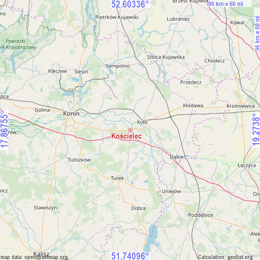
Kościelec GPS coordinates[2]
52° 10' 27.3" North, 18° 34' 14.412" East
| Map corner | latitude | longitude |
|---|---|---|
| Upper-left | 52.60336°, | 17.86755° |
| Center: | 52.17425°, | 18.57067° |
| Lower-right: | 51.74096°, | 19.2738° |
| Map W x H: | 95.9×95.9 km | = 59.6×59.6mi |
| max Lat: | 54.83135° ⇑30.6% North |
| Kościelec: | 52.17425° |
| min Lat: | ⇓69.4% South 49.21328° |
| min Long | Kościelec | max Long |
| 14.20249° | 18.57067° | 24.03723° |
| W 32.9%⇐ | ⇒67.1% E |
Elevation
Elevation of Kościelec is 102 m = 335 ft, and this is 89.4 m = 293 ft below average elevation for this country.
| Max E: |
974 m = 3196 ft | 78.8% |
| Avg. | 191.4 m = 628 ft | |
| Kościelec | 102 m = 335 ft | |
Min E: |
-3 m = -10 ft | 21.2% |
See also: Poland elevation on elevation.city.
Geographical zone
Kościelec is located in North temperate zone (between Tropic of Cancer and the Arctic Circle). Distance of this North polar circle is 1599.9 km =994.1 mi to North.| Distance of | km | miles | from Kościelec |
|---|---|---|---|
| North Pole | 4205.8 | 2613.4 | to North |
| Arctic Circle | 1599.9 | 994.1 | to North |
| Tropic Cancer | 3195.3 | 1985.5 | to South |
| Equator | 5801.2 | 3604.7 | to South |


Nearby cities:
15 places around Kościelec: (largest is in red/bold)
• Babiak
20.1 km =12.5 mi,  18°
18°
• Brudzew
8.6 km =5.3 mi,  164°
164°
• Dąbie
19.8 km =12.3 mi,  119°
119°
• Grzegorzew
11.6 km =7.2 mi,  74°
74°
• Koło
5.5 km =3.4 mi,  58°
58°
• Kramsk
14.2 km =8.8 mi,  315°
315°
• Krzymów
9.7 km =6 mi,  280°
280°
• Licheń Stary
21.2 km =13.2 mi, 316°
• Olszówka
20 km =12.4 mi,  84°
84°
• Osiek Mały
11.6 km =7.2 mi,  10°
10°
• Paprotnia
10.2 km =6.3 mi,  270°
270°
• Russocice
9.2 km =5.7 mi,  221°
221°
• Tarnowa
16.1 km =10 mi,  237°
237°
• Turek
18.3 km =11.4 mi,  195°
195°
• Władysławów
10.2 km =6.3 mi, 219°
Sources, notices
• [Note1] Compared only with cities in Poland existing in our database
• [Src1] Map data: © OpenStreetMap contributors (CC-BY-SA)
• [Src2] Other city data from geonames.org with taken over terms of usage.
• [Src3] Geographical zone / Annual Mean Temperature by Robert A. Rohde @ Wikipedia
