Koło geodata
Koło (Greater Poland) is a seat of a second-order administrative division; located in Poland in Europe/Warsaw (GMT+2) time zone. With population of 23,493 people, there are 205 cities with bigger population in this country. Compared to other cities in Poland, 70.1% of cities are located further ↓South; 65.8% of cities are located further →East and 81.8% of cities have higher elevation than Koło. Note1


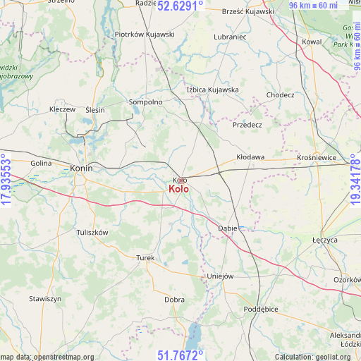
Koło GPS coordinates[2]
52° 12' 0.864" North, 18° 38' 19.14" East
| Map corner | latitude | longitude |
|---|---|---|
| Upper-left | 52.6291°, | 17.93553° |
| Center: | 52.20024°, | 18.63865° |
| Lower-right: | 51.7672°, | 19.34178° |
| Map W x H: | 95.8×95.8 km | = 59.5×59.5mi |
| max Lat: | 54.83135° ⇑29.9% North |
| Koło: | 52.20024° |
| min Lat: | ⇓70.1% South 49.21328° |
| min Long | Koło | max Long |
| 14.20249° | 18.63865° | 24.03723° |
| W 34.2%⇐ | ⇒65.8% E |
Elevation
Elevation of Koło is 96 m = 315 ft, and this is 95.4 m = 313 ft below average elevation for this country.
| Max E: |
974 m = 3196 ft | 81.8% |
| Avg. | 191.4 m = 628 ft | |
| Koło | 96 m = 315 ft | |
Min E: |
-3 m = -10 ft | 18.2% |
See also: Poland elevation on elevation.city.
Geographical zone
Koło is located in North temperate zone (between Tropic of Cancer and the Arctic Circle). Distance of this North polar circle is 1597.1 km =992.4 mi to North.| Distance of | km | miles | from Koło |
|---|---|---|---|
| North Pole | 4202.9 | 2611.6 | to North |
| Arctic Circle | 1597.1 | 992.4 | to North |
| Tropic Cancer | 3198.2 | 1987.3 | to South |
| Equator | 5804.1 | 3606.5 | to South |


Nearby cities:
15 places around Koło: (largest is in red/bold)
• Babiak
16.2 km =10.1 mi,  6°
6°
• Brdów
18.2 km =11.3 mi,  19°
19°
• Brudzew
11.4 km =7.1 mi,  191°
191°
• Dąbie
17.8 km =11.1 mi,  135°
135°
• Grzegorzew
6.5 km =4 mi,  88°
88°
• Kościelec
5.5 km =3.4 mi,  238°
238°
• Kramsk
16.3 km =10.1 mi,  296°
296°
• Krzymów
14.2 km =8.8 mi,  265°
265°
• Kłodawa
19.7 km =12.2 mi,  72°
72°
• Olszówka
15.3 km =9.5 mi, 94°
• Osiek Mały
8.8 km =5.5 mi,  343°
343°
• Paprotnia
15.1 km =9.4 mi,  259°
259°
• Russocice
14.6 km =9.1 mi,  227°
227°
• Tarnowa
21.6 km =13.4 mi, 237°
• Władysławów
15.5 km =9.6 mi, 225°
Sources, notices
• [Note1] Compared only with cities in Poland existing in our database
• [Src1] Map data: © OpenStreetMap contributors (CC-BY-SA)
• [Src2] Other city data from geonames.org with taken over terms of usage.
• [Src3] Geographical zone / Annual Mean Temperature by Robert A. Rohde @ Wikipedia
