Tuliszków geodata
Tuliszków (Greater Poland) is a seat of a third-order administrative division; located in Poland in Europe/Warsaw (GMT+2) time zone. With population of 3,371 people, there are 948 cities with bigger population in this country. Compared to other cities in Poland, 67.1% of cities are located further ↓South; 71.5% of cities are located further →East and 66.1% of cities have higher elevation than Tuliszków. Note1


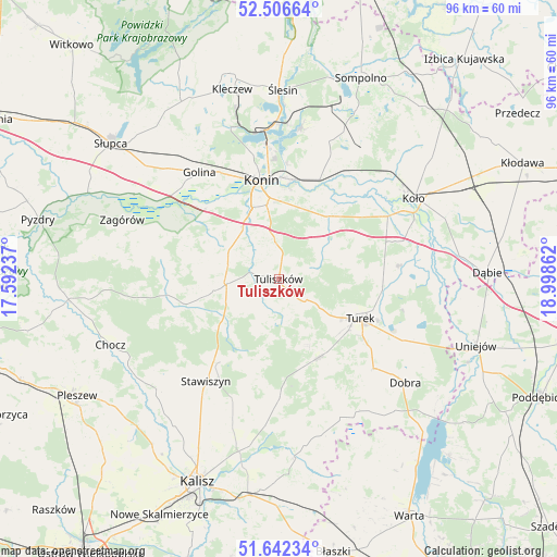
Tuliszków GPS coordinates[2]
52° 4' 35.688" North, 18° 17' 43.764" East
| Map corner | latitude | longitude |
|---|---|---|
| Upper-left | 52.50664°, | 17.59237° |
| Center: | 52.07658°, | 18.29549° |
| Lower-right: | 51.64234°, | 18.99862° |
| Map W x H: | 96.1×96.1 km | = 59.7×59.7mi |
| max Lat: | 54.83135° ⇑32.9% North |
| Tuliszków: | 52.07658° |
| min Lat: | ⇓67.1% South 49.21328° |
| min Long | Tuliszków | max Long |
| 14.20249° | 18.29549° | 24.03723° |
| W 28.5%⇐ | ⇒71.5% E |
Elevation
Elevation of Tuliszków is 130 m = 427 ft, and this is 61.4 m = 201 ft below average elevation for this country.
| Max E: |
974 m = 3196 ft | 66.1% |
| Avg. | 191.4 m = 628 ft | |
| Tuliszków | 130 m = 427 ft | |
Min E: |
-3 m = -10 ft | 33.9% |
See also: Poland elevation on elevation.city.
Geographical zone
Tuliszków is located in North temperate zone (between Tropic of Cancer and the Arctic Circle). Distance of this North polar circle is 1610.8 km =1000.9 mi to North.| Distance of | km | miles | from Tuliszków |
|---|---|---|---|
| North Pole | 4216.7 | 2620.1 | to North |
| Arctic Circle | 1610.8 | 1000.9 | to North |
| Tropic Cancer | 3184.5 | 1978.8 | to South |
| Equator | 5790.4 | 3598 | to South |


Nearby cities:
15 places around Tuliszków: (largest is in red/bold)
• Brudzew
21.3 km =13.2 mi,  83°
83°
• Grodziec
16.7 km =10.4 mi,  255°
255°
• Konin
16.6 km =10.3 mi,  349°
349°
• Kościelec
19.6 km =12.2 mi,  196°
196°
• Kościelec
21.7 km =13.5 mi,  59°
59°
• Krzymów
15.6 km =9.7 mi,  36°
36°
• Malanów
15.2 km =9.4 mi,  154°
154°
• Paprotnia
13.9 km =8.6 mi, 38°
• Russocice
13.2 km =8.2 mi,  72°
72°
• Rychwał
8.9 km =5.5 mi,  266°
266°
• Rzgów Pierwszy
18.7 km =11.6 mi,  296°
296°
• Stare Miasto
12.7 km =7.9 mi,  334°
334°
• Tarnowa
5.6 km =3.5 mi, 68°
• Turek
15.6 km =9.7 mi,  115°
115°
• Władysławów
12.7 km =7.9 mi, 76°
Sources, notices
• [Note1] Compared only with cities in Poland existing in our database
• [Src1] Map data: © OpenStreetMap contributors (CC-BY-SA)
• [Src2] Other city data from geonames.org with taken over terms of usage.
• [Src3] Geographical zone / Annual Mean Temperature by Robert A. Rohde @ Wikipedia
