Russocice geodata
Russocice (Greater Poland) is a populated place; located in Poland in Europe/Warsaw (GMT+2) time zone. With population of 638 people, there are 3194 cities with bigger population in this country. Compared to other cities in Poland, 68.2% of cities are located further ↓South; 68.5% of cities are located further →East and 75.8% of cities have higher elevation than Russocice. Note1


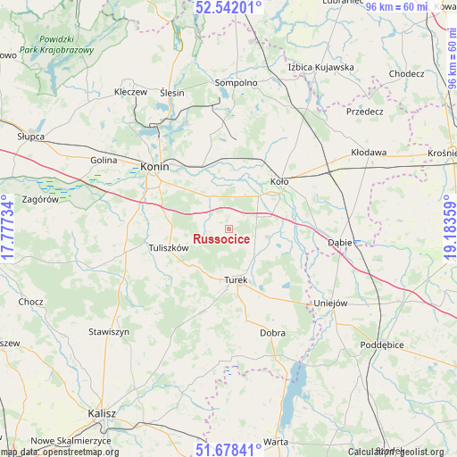
Russocice GPS coordinates[2]
52° 6' 44.28" North, 18° 28' 49.656" East
| Map corner | latitude | longitude |
|---|---|---|
| Upper-left | 52.54201°, | 17.77734° |
| Center: | 52.1123°, | 18.48046° |
| Lower-right: | 51.67841°, | 19.18359° |
| Map W x H: | 96×96 km | = 59.7×59.7mi |
| max Lat: | 54.83135° ⇑31.8% North |
| Russocice: | 52.1123° |
| min Lat: | ⇓68.2% South 49.21328° |
| min Long | Russocice | max Long |
| 14.20249° | 18.48046° | 24.03723° |
| W 31.5%⇐ | ⇒68.5% E |
Elevation
Elevation of Russocice is 109 m = 358 ft, and this is 82.4 m = 270 ft below average elevation for this country.
| Max E: |
974 m = 3196 ft | 75.8% |
| Avg. | 191.4 m = 628 ft | |
| Russocice | 109 m = 358 ft | |
Min E: |
-3 m = -10 ft | 24.2% |
See also: Poland elevation on elevation.city.
Geographical zone
Russocice is located in North temperate zone (between Tropic of Cancer and the Arctic Circle). Distance of this North polar circle is 1606.8 km =998.4 mi to North.| Distance of | km | miles | from Russocice |
|---|---|---|---|
| North Pole | 4212.7 | 2617.6 | to North |
| Arctic Circle | 1606.8 | 998.4 | to North |
| Tropic Cancer | 3188.4 | 1981.2 | to South |
| Equator | 5794.3 | 3600.4 | to South |


Nearby cities:
15 places around Russocice: (largest is in red/bold)
• Brudzew
8.6 km =5.3 mi,  99°
99°
• Konin
19.9 km =12.4 mi,  308°
308°
• Koło
14.6 km =9.1 mi,  47°
47°
• Kościelec
9.2 km =5.7 mi,  41°
41°
• Kramsk
17.4 km =10.8 mi,  347°
347°
• Krzymów
9.2 km =5.7 mi,  338°
338°
• Malanów
18.7 km =11.6 mi,  199°
199°
• Osiek Mały
20 km =12.4 mi,  24°
24°
• Paprotnia
8 km =5 mi,  329°
329°
• Przykona
17.1 km =10.6 mi,  148°
148°
• Stare Miasto
19.6 km =12.2 mi,  292°
292°
• Tarnowa
7.6 km =4.7 mi,  255°
255°
• Tuliszków
13.2 km =8.2 mi,  252°
252°
• Turek
10.9 km =6.8 mi,  172°
172°
• Władysławów
1.1 km =0.7 mi, 195°
Sources, notices
• [Note1] Compared only with cities in Poland existing in our database
• [Src1] Map data: © OpenStreetMap contributors (CC-BY-SA)
• [Src2] Other city data from geonames.org with taken over terms of usage.
• [Src3] Geographical zone / Annual Mean Temperature by Robert A. Rohde @ Wikipedia
