Brudzew geodata
Brudzew (Greater Poland) is a seat of a third-order administrative division; located in Poland in Europe/Warsaw (GMT+2) time zone. With population of 1,620 people, there are 1742 cities with bigger population in this country. Compared to other cities in Poland, 67.8% of cities are located further ↓South; 66.5% of cities are located further →East and 80.2% of cities have higher elevation than Brudzew. Note1


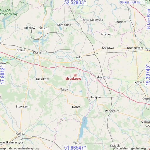
Brudzew GPS coordinates[2]
52° 5' 58.164" North, 18° 36' 15.552" East
| Map corner | latitude | longitude |
|---|---|---|
| Upper-left | 52.52933°, | 17.9012° |
| Center: | 52.09949°, | 18.60432° |
| Lower-right: | 51.66547°, | 19.30745° |
| Map W x H: | 96.1×96 km | = 59.7×59.7mi |
| max Lat: | 54.83135° ⇑32.2% North |
| Brudzew: | 52.09949° |
| min Lat: | ⇓67.8% South 49.21328° |
| min Long | Brudzew | max Long |
| 14.20249° | 18.60432° | 24.03723° |
| W 33.5%⇐ | ⇒66.5% E |
Elevation
Elevation of Brudzew is 99 m = 325 ft, and this is 92.4 m = 303 ft below average elevation for this country.
| Max E: |
974 m = 3196 ft | 80.2% |
| Avg. | 191.4 m = 628 ft | |
| Brudzew | 99 m = 325 ft | |
Min E: |
-3 m = -10 ft | 19.8% |
See also: Poland elevation on elevation.city.
Geographical zone
Brudzew is located in North temperate zone (between Tropic of Cancer and the Arctic Circle). Distance of this North polar circle is 1608.3 km =999.4 mi to North.| Distance of | km | miles | from Brudzew |
|---|---|---|---|
| North Pole | 4214.1 | 2618.5 | to North |
| Arctic Circle | 1608.3 | 999.4 | to North |
| Tropic Cancer | 3187 | 1980.3 | to South |
| Equator | 5792.9 | 3599.5 | to South |


Nearby cities:
15 places around Brudzew: (largest is in red/bold)
• Dobra
20.3 km =12.6 mi,  177°
177°
• Dąbie
15 km =9.3 mi,  95°
95°
• Grzegorzew
14.4 km =8.9 mi,  37°
37°
• Koło
11.4 km =7.1 mi,  11°
11°
• Kościelec
8.6 km =5.3 mi,  344°
344°
• Krzymów
15.5 km =9.6 mi,  310°
310°
• Olszówka
20.3 km =12.6 mi,  60°
60°
• Osiek Mały
19.7 km =12.2 mi,  359°
359°
• Paprotnia
15.1 km =9.4 mi,  303°
303°
• Przykona
13.1 km =8.1 mi, 177°
• Russocice
8.6 km =5.3 mi,  279°
279°
• Tarnowa
15.9 km =9.9 mi,  268°
268°
• Turek
11.7 km =7.3 mi,  217°
217°
• Uniejów
19 km =11.8 mi,  137°
137°
• Władysławów
8.8 km =5.5 mi, 272°
Sources, notices
• [Note1] Compared only with cities in Poland existing in our database
• [Src1] Map data: © OpenStreetMap contributors (CC-BY-SA)
• [Src2] Other city data from geonames.org with taken over terms of usage.
• [Src3] Geographical zone / Annual Mean Temperature by Robert A. Rohde @ Wikipedia
