Przelewice geodata
Przelewice (West Pomerania) is a seat of a third-order administrative division; located in Poland in Europe/Warsaw (GMT+2) time zone. With population of 770 people, there are 2920 cities with bigger population in this country. Compared to other cities in Poland, 85% of cities are located further ↓South; 97.5% of cities are located further →East and 92% of cities have higher elevation than Przelewice. Note1


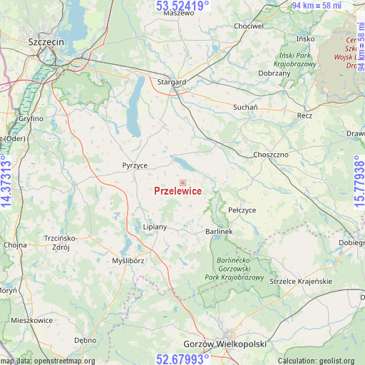
Przelewice GPS coordinates[2]
53° 6' 14.868" North, 15° 4' 34.5" East
| Map corner | latitude | longitude |
|---|---|---|
| Upper-left | 53.52419°, | 14.37313° |
| Center: | 53.10413°, | 15.07625° |
| Lower-right: | 52.67993°, | 15.77938° |
| Map W x H: | 93.9×93.9 km | = 58.3×58.3mi |
| max Lat: | 54.83135° ⇑15% North |
| Przelewice: | 53.10413° |
| min Lat: | ⇓85% South 49.21328° |
| min Long | Przelewice | max Long |
| 14.20249° | 15.07625° | 24.03723° |
| W 2.5%⇐ | ⇒97.5% E |
Elevation
Elevation of Przelewice is 65 m = 213 ft, and this is 126.4 m = 415 ft below average elevation for this country.
| Max E: |
974 m = 3196 ft | 92% |
| Avg. | 191.4 m = 628 ft | |
| Przelewice | 65 m = 213 ft | |
Min E: |
-3 m = -10 ft | 8% |
See also: Poland elevation on elevation.city.
Geographical zone
Przelewice is located in North temperate zone (between Tropic of Cancer and the Arctic Circle). Distance of this North polar circle is 1496.5 km =929.9 mi to North.| Distance of | km | miles | from Przelewice |
|---|---|---|---|
| North Pole | 4102.4 | 2549.1 | to North |
| Arctic Circle | 1496.5 | 929.9 | to North |
| Tropic Cancer | 3298.7 | 2049.7 | to South |
| Equator | 5904.6 | 3668.9 | to South |


Nearby cities:
15 places around Przelewice: (largest is in red/bold)
• Barlinek
15.5 km =9.6 mi,  141°
141°
• Bielice
25.6 km =15.9 mi,  294°
294°
• Choszczno
24.1 km =15 mi,  72°
72°
• Dolice
12.8 km =8 mi,  41°
41°
• Kozielice
16.9 km =10.5 mi,  270°
270°
• Lipiany
13.3 km =8.3 mi,  212°
212°
• Mostkowo
12.4 km =7.7 mi,  185°
185°
• Myślibórz
24.4 km =15.2 mi, 214°
• Nowogródek Pomorski
21.6 km =13.4 mi, 188°
• Pełczyce
16.7 km =10.4 mi,  113°
113°
• Pyrzyce
13.1 km =8.1 mi, 290°
• Stargard
25.9 km =16.1 mi,  356°
356°
• Suchań
25.7 km =16 mi, 40°
• Trzcinna
25 km =15.5 mi, 190°
• Warnice
17.5 km =10.9 mi,  341°
341°
Sources, notices
• [Note1] Compared only with cities in Poland existing in our database
• [Src1] Map data: © OpenStreetMap contributors (CC-BY-SA)
• [Src2] Other city data from geonames.org with taken over terms of usage.
• [Src3] Geographical zone / Annual Mean Temperature by Robert A. Rohde @ Wikipedia
