Choszczno geodata
Choszczno (West Pomerania) is a seat of a third-order administrative division; located in Poland in Europe/Warsaw (GMT+2) time zone. With population of 15,733 people, there are 318 cities with bigger population in this country. Compared to other cities in Poland, 86% of cities are located further ↓South; 95.8% of cities are located further →East and 94% of cities have higher elevation than Choszczno. Note1


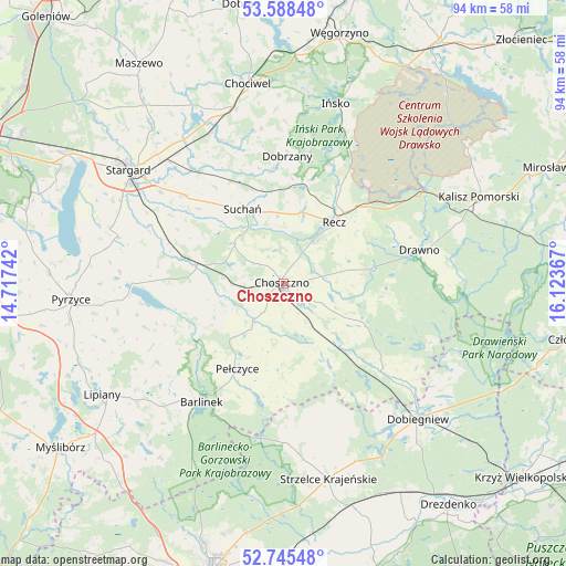
Choszczno GPS coordinates[2]
53° 10' 8.58" North, 15° 25' 13.944" East
| Map corner | latitude | longitude |
|---|---|---|
| Upper-left | 53.58848°, | 14.71742° |
| Center: | 53.16905°, | 15.42054° |
| Lower-right: | 52.74548°, | 16.12367° |
| Map W x H: | 93.7×93.7 km | = 58.2×58.2mi |
| max Lat: | 54.83135° ⇑14% North |
| Choszczno: | 53.16905° |
| min Lat: | ⇓86% South 49.21328° |
| min Long | Choszczno | max Long |
| 14.20249° | 15.42054° | 24.03723° |
| W 4.2%⇐ | ⇒95.8% E |
Elevation
Elevation of Choszczno is 54 m = 177 ft, and this is 137.4 m = 451 ft below average elevation for this country.
| Max E: |
974 m = 3196 ft | 94% |
| Avg. | 191.4 m = 628 ft | |
| Choszczno | 54 m = 177 ft | |
Min E: |
-3 m = -10 ft | 6% |
See also: Poland elevation on elevation.city.
Geographical zone
Choszczno is located in North temperate zone (between Tropic of Cancer and the Arctic Circle). Distance of this North polar circle is 1489.3 km =925.4 mi to North.| Distance of | km | miles | from Choszczno |
|---|---|---|---|
| North Pole | 4095.2 | 2544.6 | to North |
| Arctic Circle | 1489.3 | 925.4 | to North |
| Tropic Cancer | 3305.9 | 2054.2 | to South |
| Equator | 5911.8 | 3673.4 | to South |


Nearby cities:
15 places around Choszczno: (largest is in red/bold)
• Barlinek
23.6 km =14.7 mi,  214°
214°
• Bierzwnik
22.1 km =13.7 mi,  132°
132°
• Dobrzany
21.1 km =13.1 mi,  1°
1°
• Dolice
14.7 km =9.1 mi,  279°
279°
• Drawno
23.3 km =14.5 mi,  75°
75°
• Ińsko
30.9 km =19.2 mi,  16°
16°
• Krzęcin
10.8 km =6.7 mi,  154°
154°
• Marianowo
25.9 km =16.1 mi,  336°
336°
• Mostkowo
31.2 km =19.4 mi,  231°
231°
• Pełczyce
16 km =9.9 mi, 209°
• Przelewice
24.1 km =15 mi,  252°
252°
• Recz
13.2 km =8.2 mi,  39°
39°
• Stargard
30.9 km =19.2 mi,  307°
307°
• Suchań
13.9 km =8.6 mi,  332°
332°
• Warnice
29.9 km =18.6 mi,  288°
288°
Sources, notices
• [Note1] Compared only with cities in Poland existing in our database
• [Src1] Map data: © OpenStreetMap contributors (CC-BY-SA)
• [Src2] Other city data from geonames.org with taken over terms of usage.
• [Src3] Geographical zone / Annual Mean Temperature by Robert A. Rohde @ Wikipedia
