Krynica Morska geodata
Krynica Morska (Pomerania) is a populated place; located in Poland in Europe/Warsaw (GMT+2) time zone. With population of 1,339 people, there are 2025 cities with bigger population in this country. Compared to other cities in Poland, 98.3% of cities are located further ↓South; 52% of cities are located further →East and 99.3% of cities have higher elevation than Krynica Morska. Note1


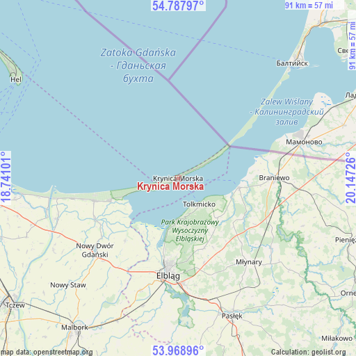
Krynica Morska GPS coordinates[2]
54° 22' 49.836" North, 19° 26' 38.868" East
| Map corner | latitude | longitude |
|---|---|---|
| Upper-left | 54.78797°, | 18.74101° |
| Center: | 54.38051°, | 19.44413° |
| Lower-right: | 53.96896°, | 20.14726° |
| Map W x H: | 91.1×91.1 km | = 56.6×56.6mi |
| max Lat: | 54.83135° ⇑1.7% North |
| Krynica Morska: | 54.38051° |
| min Lat: | ⇓98.3% South 49.21328° |
| min Long | Krynica Morska | max Long |
| 14.20249° | 19.44413° | 24.03723° |
| W 48%⇐ | ⇒52% E |
Elevation
Elevation of Krynica Morska is 3 m = 10 ft, and this is 188.4 m = 618 ft below average elevation for this country.
| Max E: |
974 m = 3196 ft | 99.3% |
| Avg. | 191.4 m = 628 ft | |
| Krynica Morska | 3 m = 10 ft | |
Min E: |
-3 m = -10 ft | 0.7% |
See also: Poland elevation on elevation.city.
Geographical zone
Krynica Morska is located in North temperate zone (between Tropic of Cancer and the Arctic Circle). Distance of this North polar circle is 1354.6 km =841.7 mi to North.| Distance of | km | miles | from Krynica Morska |
|---|---|---|---|
| North Pole | 3960.5 | 2460.9 | to North |
| Arctic Circle | 1354.6 | 841.7 | to North |
| Tropic Cancer | 3440.6 | 2137.9 | to South |
| Equator | 6046.5 | 3757.1 | to South |


Nearby cities:
15 places around Krynica Morska: (largest is in red/bold)
• Braniewo
24.3 km =15.1 mi,  90°
90°
• Elbląg
25.5 km =15.8 mi,  185°
185°
• Frombork
15.5 km =9.6 mi,  99°
99°
• Gronowo Górne
26.9 km =16.7 mi,  177°
177°
• Jantar
27.1 km =16.8 mi,  259°
259°
• Kamiennik Wielki
22.7 km =14.1 mi,  163°
163°
• Kmiecin
28.7 km =17.8 mi,  222°
222°
• Kąty Rybackie
14.6 km =9.1 mi,  251°
251°
• Marzęcino
21.1 km =13.1 mi, 220°
• Młynary
28.1 km =17.5 mi,  140°
140°
• Nowy Dwór Gdański
28.2 km =17.5 mi,  228°
228°
• Stegna
22.3 km =13.9 mi, 254°
• Suchacz
10.5 km =6.5 mi, 179°
• Sztutowo
18.2 km =11.3 mi, 250°
• Tolkmicko
8.6 km =5.3 mi, 141°
Sources, notices
• [Note1] Compared only with cities in Poland existing in our database
• [Src1] Map data: © OpenStreetMap contributors (CC-BY-SA)
• [Src2] Other city data from geonames.org with taken over terms of usage.
• [Src3] Geographical zone / Annual Mean Temperature by Robert A. Rohde @ Wikipedia
