Braniewo geodata
Braniewo (Warmia-Masuria) is a seat of a second-order administrative division; located in Poland in Europe/Warsaw (GMT+2) time zone. With population of 18,356 people, there are 268 cities with bigger population in this country. Compared to other cities in Poland, 98.3% of cities are located further ↓South; 55.3% of cities are located further ←West and 97.7% of cities have higher elevation than Braniewo. Note1


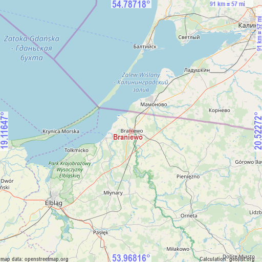
Braniewo GPS coordinates[2]
54° 22' 46.956" North, 19° 49' 10.524" East
| Map corner | latitude | longitude |
|---|---|---|
| Upper-left | 54.78718°, | 19.11647° |
| Center: | 54.37971°, | 19.81959° |
| Lower-right: | 53.96816°, | 20.52272° |
| Map W x H: | 91.1×91.1 km | = 56.6×56.6mi |
| max Lat: | 54.83135° ⇑1.7% North |
| Braniewo: | 54.37971° |
| min Lat: | ⇓98.3% South 49.21328° |
| min Long | Braniewo | max Long |
| 14.20249° | 19.81959° | 24.03723° |
| W 55.3%⇐ | ⇒44.7% E |
Elevation
Elevation of Braniewo is 17 m = 56 ft, and this is 174.4 m = 572 ft below average elevation for this country.
| Max E: |
974 m = 3196 ft | 97.7% |
| Avg. | 191.4 m = 628 ft | |
| Braniewo | 17 m = 56 ft | |
Min E: |
-3 m = -10 ft | 2.3% |
See also: Poland elevation on elevation.city.
Geographical zone
Braniewo is located in North temperate zone (between Tropic of Cancer and the Arctic Circle). Distance of this North polar circle is 1354.7 km =841.8 mi to North.| Distance of | km | miles | from Braniewo |
|---|---|---|---|
| North Pole | 3960.6 | 2461 | to North |
| Arctic Circle | 1354.7 | 841.8 | to North |
| Tropic Cancer | 3440.5 | 2137.8 | to South |
| Equator | 6046.5 | 3757.1 | to South |


Nearby cities:
15 places around Braniewo: (largest is in red/bold)
• Elbląg
36.8 km =22.9 mi,  226°
226°
• Frombork
9.4 km =5.8 mi,  254°
254°
• Gronowo Górne
35.6 km =22.1 mi,  221°
221°
• Kamiennik Wielki
28 km =17.4 mi, 219°
• Krynica Morska
24.3 km =15.1 mi,  270°
270°
• Kąty Rybackie
38.5 km =23.9 mi,  263°
263°
• Lelkowo
27 km =16.8 mi,  103°
103°
• Marzęcino
41.2 km =25.6 mi, 247°
• Młynary
22.4 km =13.9 mi,  196°
196°
• Orneta
35.8 km =22.2 mi,  145°
145°
• Pasłęk
36.9 km =22.9 mi, 196°
• Pieniężno
25.6 km =15.9 mi,  128°
128°
• Suchacz
26.4 km =16.4 mi, 246°
• Sztutowo
41.9 km =26 mi, 261°
• Tolkmicko
20.1 km =12.5 mi, 250°
In other languages:
- In German: Braunsberg, Ostpreußen, Braniewo
- In Russian: Бранево
- In Chinese: 布拉涅沃
Sources, notices
• [Note1] Compared only with cities in Poland existing in our database
• [Src1] Map data: © OpenStreetMap contributors (CC-BY-SA)
• [Src2] Other city data from geonames.org with taken over terms of usage.
• [Src3] Geographical zone / Annual Mean Temperature by Robert A. Rohde @ Wikipedia
