Frombork geodata
Frombork (Warmia-Masuria) is a seat of a third-order administrative division; located in Poland in Europe/Warsaw (GMT+2) time zone. With population of 2,529 people, there are 1231 cities with bigger population in this country. Compared to other cities in Poland, 98.1% of cities are located further ↓South; 52.3% of cities are located further ←West and 98.8% of cities have higher elevation than Frombork. Note1


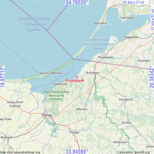
Frombork GPS coordinates[2]
54° 21' 27.576" North, 19° 40' 49.044" East
| Map corner | latitude | longitude |
|---|---|---|
| Upper-left | 54.76535°, | 18.97717° |
| Center: | 54.35766°, | 19.68029° |
| Lower-right: | 53.94589°, | 20.38342° |
| Map W x H: | 91.1×91.1 km | = 56.6×56.6mi |
| max Lat: | 54.83135° ⇑1.9% North |
| Frombork: | 54.35766° |
| min Lat: | ⇓98.1% South 49.21328° |
| min Long | Frombork | max Long |
| 14.20249° | 19.68029° | 24.03723° |
| W 52.3%⇐ | ⇒47.7% E |
Elevation
Elevation of Frombork is 6 m = 20 ft, and this is 185.4 m = 608 ft below average elevation for this country.
| Max E: |
974 m = 3196 ft | 98.8% |
| Avg. | 191.4 m = 628 ft | |
| Frombork | 6 m = 20 ft | |
Min E: |
-3 m = -10 ft | 1.2% |
See also: Poland elevation on elevation.city.
Geographical zone
Frombork is located in North temperate zone (between Tropic of Cancer and the Arctic Circle). Distance of this North polar circle is 1357.2 km =843.3 mi to North.| Distance of | km | miles | from Frombork |
|---|---|---|---|
| North Pole | 3963.1 | 2462.6 | to North |
| Arctic Circle | 1357.2 | 843.3 | to North |
| Tropic Cancer | 3438.1 | 2136.3 | to South |
| Equator | 6044 | 3755.6 | to South |


Nearby cities:
15 places around Frombork: (largest is in red/bold)
• Braniewo
9.4 km =5.8 mi,  74°
74°
• Elbląg
28.9 km =18 mi,  217°
217°
• Gronowo Górne
28.3 km =17.6 mi,  210°
210°
• Kamiennik Wielki
21.1 km =13.1 mi,  204°
204°
• Krynica Morska
15.5 km =9.6 mi,  279°
279°
• Kąty Rybackie
29.3 km =18.2 mi,  266°
266°
• Lelkowo
35.5 km =22.1 mi,  95°
95°
• Marzęcino
31.9 km =19.8 mi,  244°
244°
• Młynary
19.2 km =11.9 mi,  171°
171°
• Pasłęk
32.9 km =20.4 mi,  182°
182°
• Pieniężno
32 km =19.9 mi,  114°
114°
• Stegna
37 km =23 mi,  264°
264°
• Suchacz
17.2 km =10.7 mi, 242°
• Sztutowo
32.7 km =20.3 mi, 263°
• Tolkmicko
10.8 km =6.7 mi,  247°
247°
Sources, notices
• [Note1] Compared only with cities in Poland existing in our database
• [Src1] Map data: © OpenStreetMap contributors (CC-BY-SA)
• [Src2] Other city data from geonames.org with taken over terms of usage.
• [Src3] Geographical zone / Annual Mean Temperature by Robert A. Rohde @ Wikipedia
