Broniszewice geodata
Broniszewice (Greater Poland) is a populated place; located in Poland in Europe/Warsaw (GMT+2) time zone. With population of 1,102 people, there are 2303 cities with bigger population in this country. Compared to other cities in Poland, 65.1% of cities are located further ↓South; 77% of cities are located further →East and 81.8% of cities have higher elevation than Broniszewice. Note1


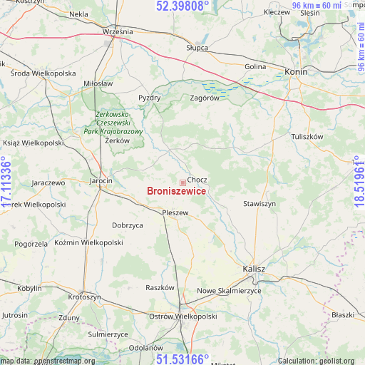
Broniszewice GPS coordinates[2]
51° 58' 1.056" North, 17° 48' 59.328" East
| Map corner | latitude | longitude |
|---|---|---|
| Upper-left | 52.39808°, | 17.11336° |
| Center: | 51.96696°, | 17.81648° |
| Lower-right: | 51.53166°, | 18.51961° |
| Map W x H: | 96.3×96.3 km | = 59.8×59.8mi |
| max Lat: | 54.83135° ⇑34.9% North |
| Broniszewice: | 51.96696° |
| min Lat: | ⇓65.1% South 49.21328° |
| min Long | Broniszewice | max Long |
| 14.20249° | 17.81648° | 24.03723° |
| W 23%⇐ | ⇒77% E |
Elevation
Elevation of Broniszewice is 96 m = 315 ft, and this is 95.4 m = 313 ft below average elevation for this country.
| Max E: |
974 m = 3196 ft | 81.8% |
| Avg. | 191.4 m = 628 ft | |
| Broniszewice | 96 m = 315 ft | |
Min E: |
-3 m = -10 ft | 18.2% |
See also: Poland elevation on elevation.city.
Geographical zone
Broniszewice is located in North temperate zone (between Tropic of Cancer and the Arctic Circle). Distance of this North polar circle is 1623 km =1008.5 mi to North.| Distance of | km | miles | from Broniszewice |
|---|---|---|---|
| North Pole | 4228.9 | 2627.7 | to North |
| Arctic Circle | 1623 | 1008.5 | to North |
| Tropic Cancer | 3172.3 | 1971.2 | to South |
| Equator | 5778.2 | 3590.4 | to South |


Nearby cities:
15 places around Broniszewice: (largest is in red/bold)
• Blizanów
15 km =9.3 mi,  117°
117°
• Chocz
3.8 km =2.4 mi,  73°
73°
• Czermin
5 km =3.1 mi,  247°
247°
• Dobieszczyzna
11.9 km =7.4 mi,  304°
304°
• Dobrzyca
18.4 km =11.4 mi,  232°
232°
• Gizałki
9 km =5.6 mi,  339°
339°
• Gołuchów
15.2 km =9.4 mi,  148°
148°
• Grodziec
18.5 km =11.5 mi,  64°
64°
• Kotlin
12.7 km =7.9 mi, 245°
• Lisewo
15.4 km =9.6 mi,  327°
327°
• Pleszew
8.1 km =5 mi,  195°
195°
• Sośnica
15 km =9.3 mi,  218°
218°
• Tomice
12.3 km =7.6 mi, 334°
• Witaszyce
17.7 km =11 mi,  260°
260°
• Zakrzew
19.8 km =12.3 mi, 256°
Sources, notices
• [Note1] Compared only with cities in Poland existing in our database
• [Src1] Map data: © OpenStreetMap contributors (CC-BY-SA)
• [Src2] Other city data from geonames.org with taken over terms of usage.
• [Src3] Geographical zone / Annual Mean Temperature by Robert A. Rohde @ Wikipedia
