Tomice geodata
Tomice (Greater Poland) is a populated place; located in Poland in Europe/Warsaw (GMT+2) time zone. With population of 586 people, there are 3321 cities with bigger population in this country. Compared to other cities in Poland, 66.8% of cities are located further ↓South; 77.8% of cities are located further →East and 87.8% of cities have higher elevation than Tomice. Note1


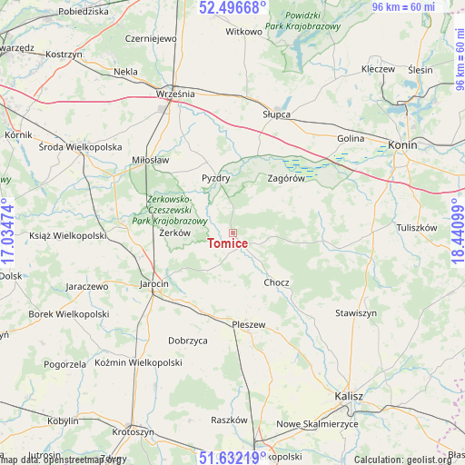
Tomice GPS coordinates[2]
52° 3' 59.508" North, 17° 44' 16.296" East
| Map corner | latitude | longitude |
|---|---|---|
| Upper-left | 52.49668°, | 17.03474° |
| Center: | 52.06653°, | 17.73786° |
| Lower-right: | 51.63219°, | 18.44099° |
| Map W x H: | 96.1×96.1 km | = 59.7×59.7mi |
| max Lat: | 54.83135° ⇑33.2% North |
| Tomice: | 52.06653° |
| min Lat: | ⇓66.8% South 49.21328° |
| min Long | Tomice | max Long |
| 14.20249° | 17.73786° | 24.03723° |
| W 22.2%⇐ | ⇒77.8% E |
Elevation
Elevation of Tomice is 82 m = 269 ft, and this is 109.4 m = 359 ft below average elevation for this country.
| Max E: |
974 m = 3196 ft | 87.8% |
| Avg. | 191.4 m = 628 ft | |
| Tomice | 82 m = 269 ft | |
Min E: |
-3 m = -10 ft | 12.2% |
See also: Poland elevation on elevation.city.
Geographical zone
Tomice is located in North temperate zone (between Tropic of Cancer and the Arctic Circle). Distance of this North polar circle is 1611.9 km =1001.6 mi to North.| Distance of | km | miles | from Tomice |
|---|---|---|---|
| North Pole | 4217.8 | 2620.8 | to North |
| Arctic Circle | 1611.9 | 1001.6 | to North |
| Tropic Cancer | 3183.3 | 1978 | to South |
| Equator | 5789.3 | 3597.3 | to South |


Nearby cities:
15 places around Tomice: (largest is in red/bold)
• Broniszewice
12.3 km =7.6 mi,  154°
154°
• Chocz
13.5 km =8.4 mi,  137°
137°
• Czermin
13 km =8.1 mi,  176°
176°
• Dobieszczyzna
6.2 km =3.9 mi,  225°
225°
• Gizałki
3.4 km =2.1 mi, 140°
• Jarocin
19.2 km =11.9 mi,  237°
237°
• Kotlin
17.5 km =10.9 mi,  200°
200°
• Kołaczkowo
18.5 km =11.5 mi,  335°
335°
• Lisewo
3.5 km =2.2 mi,  302°
302°
• Lądek
20.6 km =12.8 mi,  39°
39°
• Pleszew
19.2 km =11.9 mi,  170°
170°
• Pyzdry
12 km =7.5 mi, 344°
• Witaszyce
18.4 km =11.4 mi,  220°
220°
• Zagórów
15.6 km =9.7 mi, 43°
• Żerków
11.9 km =7.4 mi,  271°
271°
Sources, notices
• [Note1] Compared only with cities in Poland existing in our database
• [Src1] Map data: © OpenStreetMap contributors (CC-BY-SA)
• [Src2] Other city data from geonames.org with taken over terms of usage.
• [Src3] Geographical zone / Annual Mean Temperature by Robert A. Rohde @ Wikipedia
