Pleszew geodata
Pleszew (Greater Poland) is a seat of a second-order administrative division; located in Poland in Europe/Warsaw (GMT+2) time zone. With population of 17,640 people, there are 282 cities with bigger population in this country. Compared to other cities in Poland, 63.5% of cities are located further ↓South; 77.3% of cities are located further →East and 66.1% of cities have higher elevation than Pleszew. Note1


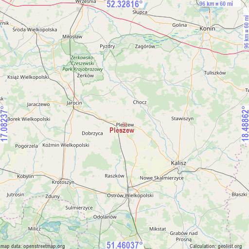
Pleszew GPS coordinates[2]
51° 53' 46.896" North, 17° 47' 7.764" East
| Map corner | latitude | longitude |
|---|---|---|
| Upper-left | 52.32816°, | 17.08237° |
| Center: | 51.89636°, | 17.78549° |
| Lower-right: | 51.46037°, | 18.48862° |
| Map W x H: | 96.5×96.5 km | = 60×60mi |
| max Lat: | 54.83135° ⇑36.5% North |
| Pleszew: | 51.89636° |
| min Lat: | ⇓63.5% South 49.21328° |
| min Long | Pleszew | max Long |
| 14.20249° | 17.78549° | 24.03723° |
| W 22.7%⇐ | ⇒77.3% E |
Elevation
Elevation of Pleszew is 130 m = 427 ft, and this is 61.4 m = 201 ft below average elevation for this country.
| Max E: |
974 m = 3196 ft | 66.1% |
| Avg. | 191.4 m = 628 ft | |
| Pleszew | 130 m = 427 ft | |
Min E: |
-3 m = -10 ft | 33.9% |
See also: Poland elevation on elevation.city.
Geographical zone
Pleszew is located in North temperate zone (between Tropic of Cancer and the Arctic Circle). Distance of this North polar circle is 1630.8 km =1013.3 mi to North.| Distance of | km | miles | from Pleszew |
|---|---|---|---|
| North Pole | 4236.7 | 2632.6 | to North |
| Arctic Circle | 1630.8 | 1013.3 | to North |
| Tropic Cancer | 3164.4 | 1966.3 | to South |
| Equator | 5770.3 | 3585.5 | to South |


Nearby cities:
15 places around Pleszew: (largest is in red/bold)
• Blizanów
15.4 km =9.6 mi,  86°
86°
• Broniszewice
8.1 km =5 mi,  15°
15°
• Chocz
10.6 km =6.6 mi,  33°
33°
• Czermin
6.5 km =4 mi,  337°
337°
• Dobieszczyzna
16.4 km =10.2 mi,  332°
332°
• Dobrzyca
12.9 km =8 mi,  255°
255°
• Gizałki
16.3 km =10.1 mi,  356°
356°
• Gołuchów
11.2 km =7 mi,  117°
117°
• Korytnica
15 km =9.3 mi,  200°
200°
• Kotlin
9.7 km =6 mi,  285°
285°
• Sobótka
13.9 km =8.6 mi,  158°
158°
• Sośnica
8.2 km =5.1 mi,  241°
241°
• Tomice
19.2 km =11.9 mi,  350°
350°
• Witaszyce
16.1 km =10 mi, 288°
• Zakrzew
17.4 km =10.8 mi,  280°
280°
Sources, notices
• [Note1] Compared only with cities in Poland existing in our database
• [Src1] Map data: © OpenStreetMap contributors (CC-BY-SA)
• [Src2] Other city data from geonames.org with taken over terms of usage.
• [Src3] Geographical zone / Annual Mean Temperature by Robert A. Rohde @ Wikipedia
