Czermin geodata
Czermin (Greater Poland) is a seat of a third-order administrative division; located in Poland in Europe/Warsaw (GMT+2) time zone. With population of 789 people, there are 2884 cities with bigger population in this country. Compared to other cities in Poland, 64.7% of cities are located further ↓South; 77.7% of cities are located further →East and 71.6% of cities have higher elevation than Czermin. Note1


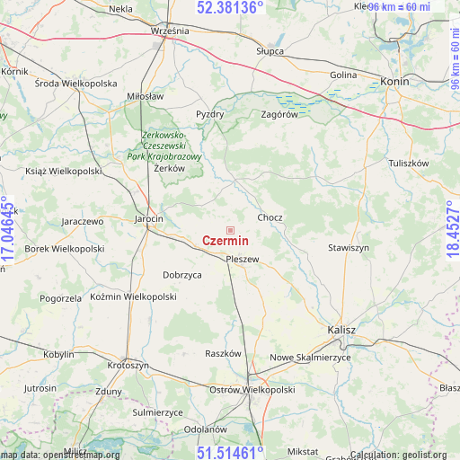
Czermin GPS coordinates[2]
51° 57' 0.288" North, 17° 44' 58.452" East
| Map corner | latitude | longitude |
|---|---|---|
| Upper-left | 52.38136°, | 17.04645° |
| Center: | 51.95008°, | 17.74957° |
| Lower-right: | 51.51461°, | 18.4527° |
| Map W x H: | 96.4×96.4 km | = 59.9×59.9mi |
| max Lat: | 54.83135° ⇑35.3% North |
| Czermin: | 51.95008° |
| min Lat: | ⇓64.7% South 49.21328° |
| min Long | Czermin | max Long |
| 14.20249° | 17.74957° | 24.03723° |
| W 22.3%⇐ | ⇒77.7% E |
Elevation
Elevation of Czermin is 118 m = 387 ft, and this is 73.4 m = 241 ft below average elevation for this country.
| Max E: |
974 m = 3196 ft | 71.6% |
| Avg. | 191.4 m = 628 ft | |
| Czermin | 118 m = 387 ft | |
Min E: |
-3 m = -10 ft | 28.4% |
See also: Poland elevation on elevation.city.
Geographical zone
Czermin is located in North temperate zone (between Tropic of Cancer and the Arctic Circle). Distance of this North polar circle is 1624.9 km =1009.7 mi to North.| Distance of | km | miles | from Czermin |
|---|---|---|---|
| North Pole | 4230.8 | 2628.9 | to North |
| Arctic Circle | 1624.9 | 1009.7 | to North |
| Tropic Cancer | 3170.4 | 1970 | to South |
| Equator | 5776.3 | 3589.2 | to South |


Nearby cities:
15 places around Czermin: (largest is in red/bold)
• Broniszewice
5 km =3.1 mi,  67°
67°
• Chocz
8.8 km =5.5 mi, 70°
• Dobieszczyzna
10 km =6.2 mi,  328°
328°
• Dobrzyca
13.7 km =8.5 mi,  227°
227°
• Gizałki
10.4 km =6.5 mi,  7°
7°
• Gołuchów
16.7 km =10.4 mi,  131°
131°
• Jarocin
17.1 km =10.6 mi,  278°
278°
• Kotlin
7.8 km =4.8 mi,  243°
243°
• Lisewo
15.3 km =9.5 mi,  345°
345°
• Pleszew
6.5 km =4 mi,  157°
157°
• Sośnica
11 km =6.8 mi,  205°
205°
• Tomice
13 km =8.1 mi,  356°
356°
• Witaszyce
12.9 km =8 mi,  265°
265°
• Zakrzew
14.9 km =9.3 mi,  258°
258°
• Żerków
18.3 km =11.4 mi,  316°
316°
Sources, notices
• [Note1] Compared only with cities in Poland existing in our database
• [Src1] Map data: © OpenStreetMap contributors (CC-BY-SA)
• [Src2] Other city data from geonames.org with taken over terms of usage.
• [Src3] Geographical zone / Annual Mean Temperature by Robert A. Rohde @ Wikipedia
