Babiak geodata
Babiak (Greater Poland) is a seat of a third-order administrative division; located in Poland in Europe/Warsaw (GMT+2) time zone. With population of 1,500 people, there are 1837 cities with bigger population in this country. Compared to other cities in Poland, 73.5% of cities are located further ↓South; 65.5% of cities are located further →East and 72.6% of cities have higher elevation than Babiak. Note1


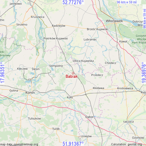
Babiak GPS coordinates[2]
52° 20' 43.08" North, 18° 39' 59.868" East
| Map corner | latitude | longitude |
|---|---|---|
| Upper-left | 52.77276°, | 17.96351° |
| Center: | 52.3453°, | 18.66663° |
| Lower-right: | 51.91367°, | 19.36976° |
| Map W x H: | 95.5×95.5 km | = 59.3×59.3mi |
| max Lat: | 54.83135° ⇑26.5% North |
| Babiak: | 52.3453° |
| min Lat: | ⇓73.5% South 49.21328° |
| min Long | Babiak | max Long |
| 14.20249° | 18.66663° | 24.03723° |
| W 34.5%⇐ | ⇒65.5% E |
Elevation
Elevation of Babiak is 116 m = 381 ft, and this is 75.4 m = 247 ft below average elevation for this country.
| Max E: |
974 m = 3196 ft | 72.6% |
| Avg. | 191.4 m = 628 ft | |
| Babiak | 116 m = 381 ft | |
Min E: |
-3 m = -10 ft | 27.4% |
See also: Poland elevation on elevation.city.
Geographical zone
Babiak is located in North temperate zone (between Tropic of Cancer and the Arctic Circle). Distance of this North polar circle is 1580.9 km =982.3 mi to North.| Distance of | km | miles | from Babiak |
|---|---|---|---|
| North Pole | 4186.8 | 2601.6 | to North |
| Arctic Circle | 1580.9 | 982.3 | to North |
| Tropic Cancer | 3214.3 | 1997.3 | to South |
| Equator | 5820.3 | 3616.6 | to South |


Nearby cities:
15 places around Babiak: (largest is in red/bold)
• Boniewo
20.2 km =12.6 mi,  48°
48°
• Brdów
4.4 km =2.7 mi,  77°
77°
• Grzegorzew
16.6 km =10.3 mi,  163°
163°
• Izbica Kujawska
10.6 km =6.6 mi,  37°
37°
• Koło
16.2 km =10.1 mi,  186°
186°
• Kościelec
20.1 km =12.5 mi,  198°
198°
• Kramsk
18.8 km =11.7 mi,  241°
241°
• Kłodawa
19.6 km =12.2 mi,  121°
121°
• Licheń Stary
21.5 km =13.4 mi,  260°
260°
• Osiek Mały
8.8 km =5.5 mi,  209°
209°
• Police
13.5 km =8.4 mi,  279°
279°
• Przedecz
15.8 km =9.8 mi,  94°
94°
• Sompolno
12.1 km =7.5 mi,  293°
293°
• Topólka
17.8 km =11.1 mi,  10°
10°
• Wierzbinek
14.9 km =9.3 mi,  314°
314°
Sources, notices
• [Note1] Compared only with cities in Poland existing in our database
• [Src1] Map data: © OpenStreetMap contributors (CC-BY-SA)
• [Src2] Other city data from geonames.org with taken over terms of usage.
• [Src3] Geographical zone / Annual Mean Temperature by Robert A. Rohde @ Wikipedia
