Dąbie geodata
Dąbie (Greater Poland) is a seat of a third-order administrative division; located in Poland in Europe/Warsaw (GMT+2) time zone. With population of 2,003 people, there are 1466 cities with bigger population in this country. Compared to other cities in Poland, 67.5% of cities are located further ↓South; 63% of cities are located further →East and 78.8% of cities have higher elevation than Dąbie. Note1


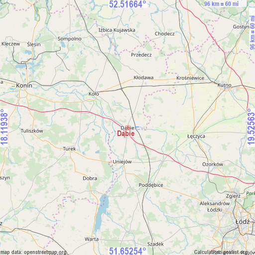
Dąbie GPS coordinates[2]
52° 5' 12.048" North, 18° 49' 21" East
| Map corner | latitude | longitude |
|---|---|---|
| Upper-left | 52.51664°, | 18.11938° |
| Center: | 52.08668°, | 18.8225° |
| Lower-right: | 51.65254°, | 19.52563° |
| Map W x H: | 96.1×96.1 km | = 59.7×59.7mi |
| max Lat: | 54.83135° ⇑32.5% North |
| Dąbie: | 52.08668° |
| min Lat: | ⇓67.5% South 49.21328° |
| min Long | Dąbie | max Long |
| 14.20249° | 18.8225° | 24.03723° |
| W 37%⇐ | ⇒63% E |
Elevation
Elevation of Dąbie is 102 m = 335 ft, and this is 89.4 m = 293 ft below average elevation for this country.
| Max E: |
974 m = 3196 ft | 78.8% |
| Avg. | 191.4 m = 628 ft | |
| Dąbie | 102 m = 335 ft | |
Min E: |
-3 m = -10 ft | 21.2% |
See also: Poland elevation on elevation.city.
Geographical zone
Dąbie is located in North temperate zone (between Tropic of Cancer and the Arctic Circle). Distance of this North polar circle is 1609.7 km =1000.2 mi to North.| Distance of | km | miles | from Dąbie |
|---|---|---|---|
| North Pole | 4215.6 | 2619.5 | to North |
| Arctic Circle | 1609.7 | 1000.2 | to North |
| Tropic Cancer | 3185.6 | 1979.4 | to South |
| Equator | 5791.5 | 3598.7 | to South |


Nearby cities:
15 places around Dąbie: (largest is in red/bold)
• Brudzew
15 km =9.3 mi,  275°
275°
• Błonie
21.5 km =13.4 mi,  92°
92°
• Chodów
22.3 km =13.9 mi,  35°
35°
• Grabów
13.1 km =8.1 mi,  69°
69°
• Grzegorzew
14.1 km =8.8 mi,  334°
334°
• Koło
17.8 km =11.1 mi,  315°
315°
• Kościelec
19.8 km =12.3 mi,  299°
299°
• Kłodawa
19.7 km =12.2 mi,  18°
18°
• Olszówka
11.8 km =7.3 mi,  13°
13°
• Poddębice
23.4 km =14.5 mi,  156°
156°
• Przykona
18.5 km =11.5 mi,  230°
230°
• Turek
23.4 km =14.5 mi,  250°
250°
• Uniejów
12.7 km =7.9 mi,  189°
189°
• Wartkowice
17.4 km =10.8 mi,  135°
135°
• Świnice Warckie
8.3 km =5.2 mi,  128°
128°
Sources, notices
• [Note1] Compared only with cities in Poland existing in our database
• [Src1] Map data: © OpenStreetMap contributors (CC-BY-SA)
• [Src2] Other city data from geonames.org with taken over terms of usage.
• [Src3] Geographical zone / Annual Mean Temperature by Robert A. Rohde @ Wikipedia
