Olszówka geodata
Olszówka (Greater Poland) is a seat of a third-order administrative division; located in Poland in Europe/Warsaw (GMT+2) time zone. With population of 440 people, there are 3573 cities with bigger population in this country. Compared to other cities in Poland, 69.8% of cities are located further ↓South; 62.5% of cities are located further →East and 75.4% of cities have higher elevation than Olszówka. Note1


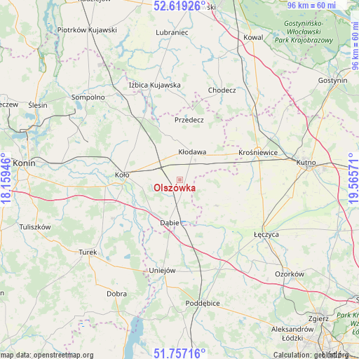
Olszówka GPS coordinates[2]
52° 11' 25.08" North, 18° 51' 45.288" East
| Map corner | latitude | longitude |
|---|---|---|
| Upper-left | 52.61926°, | 18.15946° |
| Center: | 52.1903°, | 18.86258° |
| Lower-right: | 51.75716°, | 19.56571° |
| Map W x H: | 95.9×95.9 km | = 59.6×59.6mi |
| max Lat: | 54.83135° ⇑30.2% North |
| Olszówka: | 52.1903° |
| min Lat: | ⇓69.8% South 49.21328° |
| min Long | Olszówka | max Long |
| 14.20249° | 18.86258° | 24.03723° |
| W 37.5%⇐ | ⇒62.5% E |
Elevation
Elevation of Olszówka is 110 m = 361 ft, and this is 81.4 m = 267 ft below average elevation for this country.
| Max E: |
974 m = 3196 ft | 75.4% |
| Avg. | 191.4 m = 628 ft | |
| Olszówka | 110 m = 361 ft | |
Min E: |
-3 m = -10 ft | 24.6% |
See also: Poland elevation on elevation.city.
Geographical zone
Olszówka is located in North temperate zone (between Tropic of Cancer and the Arctic Circle). Distance of this North polar circle is 1598.2 km =993.1 mi to North.| Distance of | km | miles | from Olszówka |
|---|---|---|---|
| North Pole | 4204 | 2612.2 | to North |
| Arctic Circle | 1598.2 | 993.1 | to North |
| Tropic Cancer | 3197.1 | 1986.6 | to South |
| Equator | 5803 | 3605.8 | to South |


Nearby cities:
15 places around Olszówka: (largest is in red/bold)
• Babiak
21.8 km =13.5 mi,  322°
322°
• Brdów
20.3 km =12.6 mi,  333°
333°
• Brudzew
20.3 km =12.6 mi,  240°
240°
• Chodów
12.1 km =7.5 mi,  57°
57°
• Daszyna
22.1 km =13.7 mi,  100°
100°
• Dąbie
11.8 km =7.3 mi,  193°
193°
• Dąbrowice
20.2 km =12.6 mi,  48°
48°
• Grabów
11.9 km =7.4 mi,  126°
126°
• Grzegorzew
8.8 km =5.5 mi,  278°
278°
• Koło
15.3 km =9.5 mi,  274°
274°
• Kościelec
20 km =12.4 mi,  264°
264°
• Kłodawa
7.9 km =4.9 mi,  25°
25°
• Osiek Mały
20.1 km =12.5 mi,  298°
298°
• Przedecz
16.2 km =10.1 mi,  8°
8°
• Świnice Warckie
17.1 km =10.6 mi,  167°
167°
Sources, notices
• [Note1] Compared only with cities in Poland existing in our database
• [Src1] Map data: © OpenStreetMap contributors (CC-BY-SA)
• [Src2] Other city data from geonames.org with taken over terms of usage.
• [Src3] Geographical zone / Annual Mean Temperature by Robert A. Rohde @ Wikipedia
