Rychwał geodata
Rychwał (Greater Poland) is a seat of a third-order administrative division; located in Poland in Europe/Warsaw (GMT+2) time zone. With population of 2,370 people, there are 1297 cities with bigger population in this country. Compared to other cities in Poland, 67% of cities are located further ↓South; 73.2% of cities are located further →East and 77.2% of cities have higher elevation than Rychwał. Note1


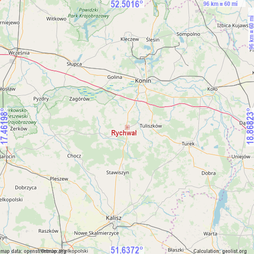
Rychwał GPS coordinates[2]
52° 4' 17.364" North, 18° 9' 54.36" East
| Map corner | latitude | longitude |
|---|---|---|
| Upper-left | 52.5016°, | 17.46198° |
| Center: | 52.07149°, | 18.1651° |
| Lower-right: | 51.6372°, | 18.86823° |
| Map W x H: | 96.1×96.1 km | = 59.7×59.7mi |
| max Lat: | 54.83135° ⇑33% North |
| Rychwał: | 52.07149° |
| min Lat: | ⇓67% South 49.21328° |
| min Long | Rychwał | max Long |
| 14.20249° | 18.1651° | 24.03723° |
| W 26.8%⇐ | ⇒73.2% E |
Elevation
Elevation of Rychwał is 105 m = 344 ft, and this is 86.4 m = 283 ft below average elevation for this country.
| Max E: |
974 m = 3196 ft | 77.2% |
| Avg. | 191.4 m = 628 ft | |
| Rychwał | 105 m = 344 ft | |
Min E: |
-3 m = -10 ft | 22.8% |
See also: Poland elevation on elevation.city.
Geographical zone
Rychwał is located in North temperate zone (between Tropic of Cancer and the Arctic Circle). Distance of this North polar circle is 1611.4 km =1001.3 mi to North.| Distance of | km | miles | from Rychwał |
|---|---|---|---|
| North Pole | 4217.3 | 2620.5 | to North |
| Arctic Circle | 1611.4 | 1001.3 | to North |
| Tropic Cancer | 3183.9 | 1978.4 | to South |
| Equator | 5789.8 | 3597.6 | to South |


Nearby cities:
15 places around Rychwał: (largest is in red/bold)
• Blizanów
21.5 km =13.4 mi,  209°
209°
• Golina
19.7 km =12.2 mi,  345°
345°
• Grodziec
8.1 km =5 mi,  243°
243°
• Konin
17.9 km =11.1 mi,  19°
19°
• Kościelec
18.5 km =11.5 mi,  169°
169°
• Malanów
20.3 km =12.6 mi,  130°
130°
• Paprotnia
20.9 km =13 mi,  56°
56°
• Russocice
22 km =13.7 mi,  78°
78°
• Rzgów Pierwszy
11.9 km =7.4 mi,  318°
318°
• Stare Miasto
12.5 km =7.8 mi, 15°
• Stawiszyn
17.5 km =10.9 mi,  192°
192°
• Tarnowa
14.4 km =8.9 mi, 79°
• Tuliszków
8.9 km =5.5 mi,  86°
86°
• Władysławów
21.5 km =13.4 mi, 80°
• Zagórów
21.3 km =13.2 mi,  300°
300°
Sources, notices
• [Note1] Compared only with cities in Poland existing in our database
• [Src1] Map data: © OpenStreetMap contributors (CC-BY-SA)
• [Src2] Other city data from geonames.org with taken over terms of usage.
• [Src3] Geographical zone / Annual Mean Temperature by Robert A. Rohde @ Wikipedia
