Złotniki geodata
Złotniki (Greater Poland) is a populated place; located in Poland in Europe/Warsaw (GMT+2) time zone. With population of 1,100 people, there are 2307 cities with bigger population in this country. Compared to other cities in Poland, 76.3% of cities are located further ↓South; 86.8% of cities are located further →East and 78.4% of cities have higher elevation than Złotniki. Note1


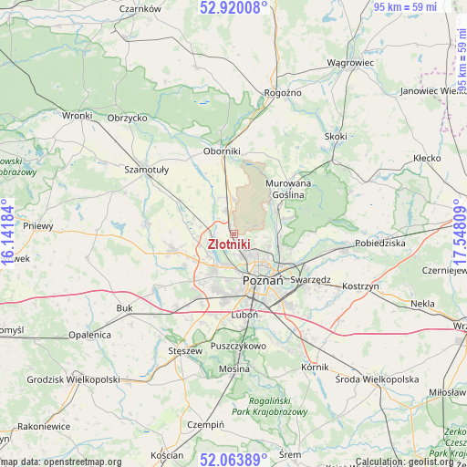
Złotniki GPS coordinates[2]
52° 29' 38.652" North, 16° 50' 41.856" East
| Map corner | latitude | longitude |
|---|---|---|
| Upper-left | 52.92008°, | 16.14184° |
| Center: | 52.49407°, | 16.84496° |
| Lower-right: | 52.06389°, | 17.54809° |
| Map W x H: | 95.2×95.2 km | = 59.2×59.2mi |
| max Lat: | 54.83135° ⇑23.7% North |
| Złotniki: | 52.49407° |
| min Lat: | ⇓76.3% South 49.21328° |
| min Long | Złotniki | max Long |
| 14.20249° | 16.84496° | 24.03723° |
| W 13.2%⇐ | ⇒86.8% E |
Elevation
Elevation of Złotniki is 103 m = 338 ft, and this is 88.4 m = 290 ft below average elevation for this country.
| Max E: |
974 m = 3196 ft | 78.4% |
| Avg. | 191.4 m = 628 ft | |
| Złotniki | 103 m = 338 ft | |
Min E: |
-3 m = -10 ft | 21.6% |
See also: Poland elevation on elevation.city.
Geographical zone
Złotniki is located in North temperate zone (between Tropic of Cancer and the Arctic Circle). Distance of this North polar circle is 1564.4 km =972.1 mi to North.| Distance of | km | miles | from Złotniki |
|---|---|---|---|
| North Pole | 4170.3 | 2591.3 | to North |
| Arctic Circle | 1564.4 | 972.1 | to North |
| Tropic Cancer | 3230.9 | 2007.6 | to South |
| Equator | 5836.8 | 3626.8 | to South |


Nearby cities:
15 places around Złotniki: (largest is in red/bold)
• Baranowo
7.7 km =4.8 mi,  211°
211°
• Czerwonak
9.8 km =6.1 mi,  109°
109°
• Kobylnica
16.6 km =10.3 mi, 108°
• Komorniki
17.4 km =10.8 mi,  187°
187°
• Luboń
16.7 km =10.4 mi,  168°
168°
• Murowana Goślina
14.3 km =8.9 mi,  51°
51°
• Objezierze
13.5 km =8.4 mi,  335°
335°
• Oborniki
17.2 km =10.7 mi,  353°
353°
• Pamiątkowo
12.9 km =8 mi,  300°
300°
• Plewiska
14.3 km =8.9 mi, 189°
• Poznań
11.3 km =7 mi,  149°
149°
• Rokietnica
7 km =4.3 mi,  286°
286°
• Suchy Las
3.2 km =2 mi,  136°
136°
• Tarnowo Podgórne
12.7 km =7.9 mi,  255°
255°
• Zakrzewo
13.8 km =8.6 mi,  216°
216°
Sources, notices
• [Note1] Compared only with cities in Poland existing in our database
• [Src1] Map data: © OpenStreetMap contributors (CC-BY-SA)
• [Src2] Other city data from geonames.org with taken over terms of usage.
• [Src3] Geographical zone / Annual Mean Temperature by Robert A. Rohde @ Wikipedia
