Czerwonak geodata
Czerwonak (Greater Poland) is a seat of a third-order administrative division; located in Poland in Europe/Warsaw (GMT+2) time zone. With population of 5,432 people, there are 646 cities with bigger population in this country. Compared to other cities in Poland, 75.8% of cities are located further ↓South; 85.1% of cities are located further →East and 92.7% of cities have higher elevation than Czerwonak. Note1


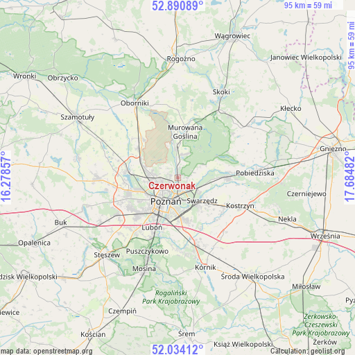
Czerwonak GPS coordinates[2]
52° 27' 52.524" North, 16° 58' 54.084" East
| Map corner | latitude | longitude |
|---|---|---|
| Upper-left | 52.89089°, | 16.27857° |
| Center: | 52.46459°, | 16.98169° |
| Lower-right: | 52.03412°, | 17.68482° |
| Map W x H: | 95.3×95.3 km | = 59.2×59.2mi |
| max Lat: | 54.83135° ⇑24.2% North |
| Czerwonak: | 52.46459° |
| min Lat: | ⇓75.8% South 49.21328° |
| min Long | Czerwonak | max Long |
| 14.20249° | 16.98169° | 24.03723° |
| W 14.9%⇐ | ⇒85.1% E |
Elevation
Elevation of Czerwonak is 61 m = 200 ft, and this is 130.4 m = 428 ft below average elevation for this country.
| Max E: |
974 m = 3196 ft | 92.7% |
| Avg. | 191.4 m = 628 ft | |
| Czerwonak | 61 m = 200 ft | |
Min E: |
-3 m = -10 ft | 7.3% |
See also: Poland elevation on elevation.city.
Geographical zone
Czerwonak is located in North temperate zone (between Tropic of Cancer and the Arctic Circle). Distance of this North polar circle is 1567.7 km =974.1 mi to North.| Distance of | km | miles | from Czerwonak |
|---|---|---|---|
| North Pole | 4173.5 | 2593.3 | to North |
| Arctic Circle | 1567.7 | 974.1 | to North |
| Tropic Cancer | 3227.6 | 2005.5 | to South |
| Equator | 5833.5 | 3624.8 | to South |


Nearby cities:
15 places around Czerwonak: (largest is in red/bold)
• Baranowo
13.6 km =8.5 mi,  256°
256°
• Czapury
17 km =10.6 mi,  195°
195°
• Daszewice
18.4 km =11.4 mi,  185°
185°
• Gądki
17.5 km =10.9 mi,  165°
165°
• Kobylnica
6.7 km =4.2 mi,  107°
107°
• Komorniki
18.2 km =11.3 mi,  219°
219°
• Kostrzyn
18.3 km =11.4 mi, 113°
• Luboń
14.4 km =8.9 mi, 204°
• Murowana Goślina
12.4 km =7.7 mi,  8°
8°
• Plewiska
15.9 km =9.9 mi,  227°
227°
• Poznań
7.3 km =4.5 mi,  208°
208°
• Rokietnica
16.8 km =10.4 mi,  288°
288°
• Suchy Las
7.1 km =4.4 mi,  277°
277°
• Swarzędz
9.1 km =5.7 mi,  129°
129°
• Złotniki
9.8 km =6.1 mi, 289°
Sources, notices
• [Note1] Compared only with cities in Poland existing in our database
• [Src1] Map data: © OpenStreetMap contributors (CC-BY-SA)
• [Src2] Other city data from geonames.org with taken over terms of usage.
• [Src3] Geographical zone / Annual Mean Temperature by Robert A. Rohde @ Wikipedia
