Suchy Las geodata
Suchy Las (Greater Poland) is a seat of a third-order administrative division; located in Poland in Europe/Warsaw (GMT+2) time zone. With population of 4,367 people, there are 754 cities with bigger population in this country. Compared to other cities in Poland, 76% of cities are located further ↓South; 86.4% of cities are located further →East and 78.8% of cities have higher elevation than Suchy Las. Note1


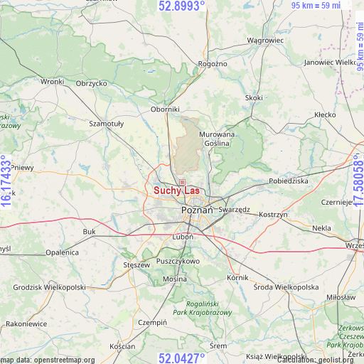
Suchy Las GPS coordinates[2]
52° 28' 23.088" North, 16° 52' 38.82" East
| Map corner | latitude | longitude |
|---|---|---|
| Upper-left | 52.8993°, | 16.17433° |
| Center: | 52.47308°, | 16.87745° |
| Lower-right: | 52.0427°, | 17.58058° |
| Map W x H: | 95.2×95.2 km | = 59.2×59.2mi |
| max Lat: | 54.83135° ⇑24% North |
| Suchy Las: | 52.47308° |
| min Lat: | ⇓76% South 49.21328° |
| min Long | Suchy Las | max Long |
| 14.20249° | 16.87745° | 24.03723° |
| W 13.6%⇐ | ⇒86.4% E |
Elevation
Elevation of Suchy Las is 102 m = 335 ft, and this is 89.4 m = 293 ft below average elevation for this country.
| Max E: |
974 m = 3196 ft | 78.8% |
| Avg. | 191.4 m = 628 ft | |
| Suchy Las | 102 m = 335 ft | |
Min E: |
-3 m = -10 ft | 21.2% |
See also: Poland elevation on elevation.city.
Geographical zone
Suchy Las is located in North temperate zone (between Tropic of Cancer and the Arctic Circle). Distance of this North polar circle is 1566.7 km =973.5 mi to North.| Distance of | km | miles | from Suchy Las |
|---|---|---|---|
| North Pole | 4172.6 | 2592.7 | to North |
| Arctic Circle | 1566.7 | 973.5 | to North |
| Tropic Cancer | 3228.5 | 2006.1 | to South |
| Equator | 5834.5 | 3625.4 | to South |


Nearby cities:
15 places around Suchy Las: (largest is in red/bold)
• Baranowo
7.5 km =4.7 mi,  235°
235°
• Czerwonak
7.1 km =4.4 mi,  97°
97°
• Kobylnica
13.8 km =8.6 mi, 102°
• Komorniki
15.6 km =9.7 mi,  196°
196°
• Luboń
14.1 km =8.8 mi,  175°
175°
• Murowana Goślina
14.4 km =8.9 mi,  38°
38°
• Objezierze
16.6 km =10.3 mi,  332°
332°
• Pamiątkowo
16 km =9.9 mi,  303°
303°
• Plewiska
12.6 km =7.8 mi, 201°
• Poznań
8.2 km =5.1 mi,  154°
154°
• Rokietnica
9.9 km =6.2 mi, 296°
• Swarzędz
15.6 km =9.7 mi,  115°
115°
• Tarnowo Podgórne
14.5 km =9 mi,  267°
267°
• Zakrzewo
13.6 km =8.5 mi,  229°
229°
• Złotniki
3.2 km =2 mi,  316°
316°
Sources, notices
• [Note1] Compared only with cities in Poland existing in our database
• [Src1] Map data: © OpenStreetMap contributors (CC-BY-SA)
• [Src2] Other city data from geonames.org with taken over terms of usage.
• [Src3] Geographical zone / Annual Mean Temperature by Robert A. Rohde @ Wikipedia
