Malbork geodata
Malbork (Pomerania) is a populated place; located in Poland in Europe/Warsaw (GMT+2) time zone. With population of 38,655 people, there are 134 cities with bigger population in this country. Compared to other cities in Poland, 94.6% of cities are located further ↓South; 59.7% of cities are located further →East and 97.7% of cities have higher elevation than Malbork. Note1


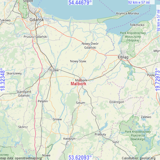
Malbork GPS coordinates[2]
54° 2' 9.276" North, 19° 1' 35.76" East
| Map corner | latitude | longitude |
|---|---|---|
| Upper-left | 54.44679°, | 18.32348° |
| Center: | 54.03591°, | 19.0266° |
| Lower-right: | 53.62093°, | 19.72973° |
| Map W x H: | 91.8×91.8 km | = 57×57mi |
| max Lat: | 54.83135° ⇑5.4% North |
| Malbork: | 54.03591° |
| min Lat: | ⇓94.6% South 49.21328° |
| min Long | Malbork | max Long |
| 14.20249° | 19.0266° | 24.03723° |
| W 40.3%⇐ | ⇒59.7% E |
Elevation
Elevation of Malbork is 17 m = 56 ft, and this is 174.4 m = 572 ft below average elevation for this country.
| Max E: |
974 m = 3196 ft | 97.7% |
| Avg. | 191.4 m = 628 ft | |
| Malbork | 17 m = 56 ft | |
Min E: |
-3 m = -10 ft | 2.3% |
See also: Poland elevation on elevation.city.
Geographical zone
Malbork is located in North temperate zone (between Tropic of Cancer and the Arctic Circle). Distance of this North polar circle is 1392.9 km =865.5 mi to North.| Distance of | km | miles | from Malbork |
|---|---|---|---|
| North Pole | 3998.8 | 2484.7 | to North |
| Arctic Circle | 1392.9 | 865.5 | to North |
| Tropic Cancer | 3402.3 | 2114.1 | to South |
| Equator | 6008.2 | 3733.3 | to South |


Nearby cities:
15 places around Malbork: (largest is in red/bold)
• Czarlin
17.4 km =10.8 mi,  275°
275°
• Gronowo Elbląskie
19.1 km =11.9 mi,  73°
73°
• Kmiecin
18.8 km =11.7 mi,  25°
25°
• Lichnowy
11.5 km =7.1 mi,  320°
320°
• Lisewo Malborskie
14.5 km =9 mi,  297°
297°
• Lubieszewo
17.2 km =10.7 mi,  2°
2°
• Miłoradz
7.5 km =4.7 mi,  250°
250°
• Nowy Staw
11.2 km =7 mi,  354°
354°
• Ostaszewo
20.2 km =12.6 mi, 345°
• Stare Pole
12.1 km =7.5 mi,  79°
79°
• Stary Targ
15.6 km =9.7 mi,  143°
143°
• Subkowy
17.2 km =10.7 mi,  257°
257°
• Sztum
12.8 km =8 mi,  178°
178°
• Tczew
17.4 km =10.8 mi,  291°
291°
• Wielkie Walichnowy
17.5 km =10.9 mi,  220°
220°
Sources, notices
• [Note1] Compared only with cities in Poland existing in our database
• [Src1] Map data: © OpenStreetMap contributors (CC-BY-SA)
• [Src2] Other city data from geonames.org with taken over terms of usage.
• [Src3] Geographical zone / Annual Mean Temperature by Robert A. Rohde @ Wikipedia
