Żytno geodata
Żytno (Łódź Voivodeship) is a populated place; located in Poland in Europe/Warsaw (GMT+2) time zone. With population of 678 people, there are 3117 cities with bigger population in this country. Compared to other cities in Poland, 57% of cities are located further ↑North; 51.4% of cities are located further ←West and 69.8% of cities have lower elevation than Żytno. Note1


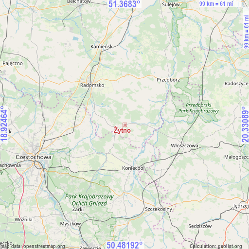
Żytno GPS coordinates[2]
50° 55' 37.992" North, 19° 37' 39.936" East
| Map corner | latitude | longitude |
|---|---|---|
| Upper-left | 51.3683°, | 18.92464° |
| Center: | 50.92722°, | 19.62776° |
| Lower-right: | 50.48192°, | 20.33089° |
| Map W x H: | 98.6×98.6 km | = 61.3×61.3mi |
| max Lat: | 54.83135° ⇑57% North |
| Żytno: | 50.92722° |
| min Lat: | ⇓43% South 49.21328° |
| min Long | Żytno | max Long |
| 14.20249° | 19.62776° | 24.03723° |
| W 51.4%⇐ | ⇒48.6% E |
Elevation
Elevation of Żytno is 229 m = 751 ft, and this is 37.6 m = 123 ft above average elevation for this country.
| Max E: |
974 m = 3196 ft | 30.2% |
| Żytno | 229 m 751 ft | |
| Avg. | 191.4 m = 628 ft | |
Min E: |
-3 m = -10 ft | 69.8% |
See also: Poland elevation on elevation.city.
Geographical zone
Żytno is located in North temperate zone (between Tropic of Cancer and the Arctic Circle). Distance of this North polar circle is 1738.6 km =1080.3 mi to North.| Distance of | km | miles | from Żytno |
|---|---|---|---|
| North Pole | 4344.5 | 2699.5 | to North |
| Arctic Circle | 1738.6 | 1080.3 | to North |
| Tropic Cancer | 3056.7 | 1899.3 | to South |
| Equator | 5662.6 | 3518.6 | to South |


Nearby cities:
15 places around Żytno: (largest is in red/bold)
• Drochlin
22 km =13.7 mi,  177°
177°
• Dąbrowa Zielona
10.5 km =6.5 mi,  208°
208°
• Gidle
11.6 km =7.2 mi,  289°
289°
• Kluczewsko
20.4 km =12.7 mi,  89°
89°
• Kobiele Wielkie
12.3 km =7.6 mi,  358°
358°
• Kodrąb
19.2 km =11.9 mi,  0°
0°
• Koniecpol
17.5 km =10.9 mi,  165°
165°
• Kłomnice
19 km =11.8 mi,  268°
268°
• Przedbórz
24.8 km =15.4 mi,  43°
43°
• Przyrów
15.7 km =9.8 mi, 206°
• Pławno
13.3 km =8.3 mi, 294°
• Radomsko
20.1 km =12.5 mi,  320°
320°
• Secemin
23.1 km =14.4 mi,  140°
140°
• Soborzyce
7.6 km =4.7 mi,  186°
186°
• Wielgomłyny
13.5 km =8.4 mi,  45°
45°
Sources, notices
• [Note1] Compared only with cities in Poland existing in our database
• [Src1] Map data: © OpenStreetMap contributors (CC-BY-SA)
• [Src2] Other city data from geonames.org with taken over terms of usage.
• [Src3] Geographical zone / Annual Mean Temperature by Robert A. Rohde @ Wikipedia
