Siedlisko geodata
Siedlisko (Lubusz) is a seat of a third-order administrative division; located in Poland in Europe/Warsaw (GMT+2) time zone. With population of 1,800 people, there are 1605 cities with bigger population in this country. Compared to other cities in Poland, 61.4% of cities are located further ↓South; 93.5% of cities are located further →East and 86.3% of cities have higher elevation than Siedlisko. Note1


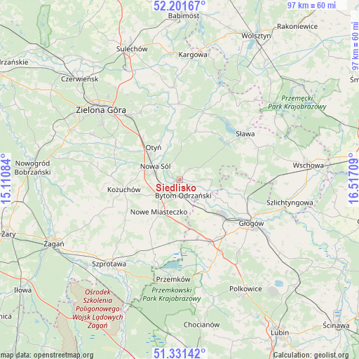
Siedlisko GPS coordinates[2]
51° 46' 7.104" North, 15° 48' 50.256" East
| Map corner | latitude | longitude |
|---|---|---|
| Upper-left | 52.20167°, | 15.11084° |
| Center: | 51.76864°, | 15.81396° |
| Lower-right: | 51.33142°, | 16.51709° |
| Map W x H: | 96.8×96.8 km | = 60.1×60.1mi |
| max Lat: | 54.83135° ⇑38.6% North |
| Siedlisko: | 51.76864° |
| min Lat: | ⇓61.4% South 49.21328° |
| min Long | Siedlisko | max Long |
| 14.20249° | 15.81396° | 24.03723° |
| W 6.5%⇐ | ⇒93.5% E |
Elevation
Elevation of Siedlisko is 86 m = 282 ft, and this is 105.4 m = 346 ft below average elevation for this country.
| Max E: |
974 m = 3196 ft | 86.3% |
| Avg. | 191.4 m = 628 ft | |
| Siedlisko | 86 m = 282 ft | |
Min E: |
-3 m = -10 ft | 13.7% |
See also: Poland elevation on elevation.city.
Geographical zone
Siedlisko is located in North temperate zone (between Tropic of Cancer and the Arctic Circle). Distance of this North polar circle is 1645 km =1022.2 mi to North.| Distance of | km | miles | from Siedlisko |
|---|---|---|---|
| North Pole | 4250.9 | 2641.4 | to North |
| Arctic Circle | 1645 | 1022.2 | to North |
| Tropic Cancer | 3150.2 | 1957.4 | to South |
| Equator | 5756.1 | 3576.7 | to South |


Nearby cities:
15 places around Siedlisko: (largest is in red/bold)
• Bielawy
8.5 km =5.3 mi,  89°
89°
• Bobrowniki
12.1 km =7.5 mi,  332°
332°
• Bojadła
20.5 km =12.7 mi,  359°
359°
• Bytom Odrzański
4.3 km =2.7 mi,  171°
171°
• Gaworzyce
16.4 km =10.2 mi,  163°
163°
• Konotop
19.1 km =11.9 mi,  18°
18°
• Kotla
15.5 km =9.6 mi,  99°
99°
• Kożuchów
15.3 km =9.5 mi,  260°
260°
• Kłobuczyn
18.8 km =11.7 mi,  154°
154°
• Lubięcin
14.2 km =8.8 mi, 17°
• Nowa Sól
7.7 km =4.8 mi,  300°
300°
• Nowe Miasteczko
10.3 km =6.4 mi,  213°
213°
• Otyń
11.3 km =7 mi,  321°
321°
• Przyborów
4.7 km =2.9 mi, 318°
• Żukowice
15.8 km =9.8 mi,  132°
132°
Sources, notices
• [Note1] Compared only with cities in Poland existing in our database
• [Src1] Map data: © OpenStreetMap contributors (CC-BY-SA)
• [Src2] Other city data from geonames.org with taken over terms of usage.
• [Src3] Geographical zone / Annual Mean Temperature by Robert A. Rohde @ Wikipedia
