Wierzchosławice geodata
Wierzchosławice (Lower Silesia) is a populated place; located in Poland in Europe/Warsaw (GMT+2) time zone. With population of 870 people, there are 2725 cities with bigger population in this country. Compared to other cities in Poland, 58% of cities are located further ↑North; 92% of cities are located further →East and 92.2% of cities have lower elevation than Wierzchosławice. Note1


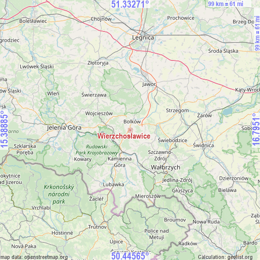
Wierzchosławice GPS coordinates[2]
50° 53' 28.644" North, 16° 5' 31.092" East
| Map corner | latitude | longitude |
|---|---|---|
| Upper-left | 51.33271°, | 15.38885° |
| Center: | 50.89129°, | 16.09197° |
| Lower-right: | 50.44565°, | 16.7951° |
| Map W x H: | 98.6×98.6 km | = 61.3×61.3mi |
| max Lat: | 54.83135° ⇑58% North |
| Wierzchosławice: | 50.89129° |
| min Lat: | ⇓42% South 49.21328° |
| min Long | Wierzchosławic | max Long |
| 14.20249° | 16.09197° | 24.03723° |
| W 8%⇐ | ⇒92% E |
Elevation
Elevation of Wierzchosławice is 360 m = 1181 ft, and this is 168.6 m = 553 ft above average elevation for this country.
| Max E: |
974 m = 3196 ft | 7.8% |
| Wierzchosławice | 360 m 1181 ft | |
| Avg. | 191.4 m = 628 ft | |
Min E: |
-3 m = -10 ft | 92.2% |
See also: Poland elevation on elevation.city.
Geographical zone
Wierzchosławice is located in North temperate zone (between Tropic of Cancer and the Arctic Circle). Distance of this North polar circle is 1742.6 km =1082.8 mi to North.| Distance of | km | miles | from Wierzchosławice |
|---|---|---|---|
| North Pole | 4348.5 | 2702 | to North |
| Arctic Circle | 1742.6 | 1082.8 | to North |
| Tropic Cancer | 3052.7 | 1896.9 | to South |
| Equator | 5658.6 | 3516.1 | to South |


Nearby cities:
15 places around Wierzchosławice: (largest is in red/bold)
• Boguszów-Gorce
17.1 km =10.6 mi,  152°
152°
• Bolków
3.5 km =2.2 mi,  10°
10°
• Czarny Bór
13.7 km =8.5 mi,  168°
168°
• Dobromierz
10.7 km =6.6 mi,  77°
77°
• Janowice Wielkie
12 km =7.5 mi,  261°
261°
• Jawor
19.2 km =11.9 mi,  21°
21°
• Kamienna Góra
12.8 km =8 mi,  199°
199°
• Krzeszów
17.5 km =10.9 mi,  185°
185°
• Marciszów
7.2 km =4.5 mi,  223°
223°
• Paszowice
14 km =8.7 mi, 17°
• Stare Bogaczowice
8.6 km =5.3 mi,  124°
124°
• Szczawno-Zdrój
15.1 km =9.4 mi,  130°
130°
• Wałbrzych
19 km =11.8 mi, 134°
• Wojcieszów
13.7 km =8.5 mi,  299°
299°
• Świebodzice
16.4 km =10.2 mi,  102°
102°
Sources, notices
• [Note1] Compared only with cities in Poland existing in our database
• [Src1] Map data: © OpenStreetMap contributors (CC-BY-SA)
• [Src2] Other city data from geonames.org with taken over terms of usage.
• [Src3] Geographical zone / Annual Mean Temperature by Robert A. Rohde @ Wikipedia
